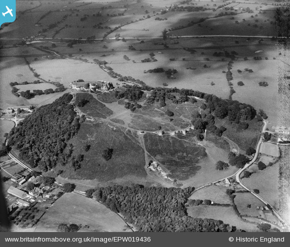
epw019436 ENGLAND (1927). Beeston Castle, Beeston, 1927
© Copyright OpenStreetMap contributors and licensed by the OpenStreetMap Foundation. 2024. Cartography is licensed as CC BY-SA.
Nearby Images (13)
Details
| Title | [EPW019436] Beeston Castle, Beeston, 1927 |
| Reference | EPW019436 |
| Date | October-1927 |
| Link | |
| Place name | BEESTON |
| Parish | BEESTON |
| District | |
| Country | ENGLAND |
| Easting / Northing | 353820, 359166 |
| Longitude / Latitude | -2.6902239673796, 53.12736427709 |
| National Grid Reference | SJ538592 |
Pins
Be the first to add a comment to this image!
User Comment Contributions
 BruceR |
Wednesday 5th of December 2012 09:53:05 PM |


![[EPW019436] Beeston Castle, Beeston, 1927](http://britainfromabove.org.uk/sites/all/libraries/aerofilms-images/public/100x100/EPW/019/EPW019436.jpg)
![[EAW013789] Beeston Castle, Beeston, 1948. This image has been produced from a print.](http://britainfromabove.org.uk/sites/all/libraries/aerofilms-images/public/100x100/EAW/013/EAW013789.jpg)
![[EPW019438] Beeston Castle, Beeston, 1927](http://britainfromabove.org.uk/sites/all/libraries/aerofilms-images/public/100x100/EPW/019/EPW019438.jpg)
![[EPW040170] Beeston Castle, Beeston, 1932](http://britainfromabove.org.uk/sites/all/libraries/aerofilms-images/public/100x100/EPW/040/EPW040170.jpg)
![[EAW013792] Beeston Castle, Beeston, 1948](http://britainfromabove.org.uk/sites/all/libraries/aerofilms-images/public/100x100/EAW/013/EAW013792.jpg)
![[EAW013790] Beeston Castle and Castlegate Farm, Beeston, 1948. This image has been produced from a damaged negative.](http://britainfromabove.org.uk/sites/all/libraries/aerofilms-images/public/100x100/EAW/013/EAW013790.jpg)
![[EAW013793] Beeston Castle, Beeston, 1948](http://britainfromabove.org.uk/sites/all/libraries/aerofilms-images/public/100x100/EAW/013/EAW013793.jpg)
![[EPW040172] Beeston Castle, Beeston, 1932](http://britainfromabove.org.uk/sites/all/libraries/aerofilms-images/public/100x100/EPW/040/EPW040172.jpg)
![[EPW040171] Beeston Castle Keep, Beeston, 1932](http://britainfromabove.org.uk/sites/all/libraries/aerofilms-images/public/100x100/EPW/040/EPW040171.jpg)
![[EPW019437] Beeston Castle, Beeston, from the south-east, 1927](http://britainfromabove.org.uk/sites/all/libraries/aerofilms-images/public/100x100/EPW/019/EPW019437.jpg)
![[EAW000832] Beeston Castle and surrounding countryside, Beeston, from the north-east, 1946](http://britainfromabove.org.uk/sites/all/libraries/aerofilms-images/public/100x100/EAW/000/EAW000832.jpg)
![[EAW013794] Beeston Castle, Beeston, 1948](http://britainfromabove.org.uk/sites/all/libraries/aerofilms-images/public/100x100/EAW/013/EAW013794.jpg)
![[EAW013791] Beeston Castle, Beeston, from the north, 1948. This image has been produced from a damaged negative.](http://britainfromabove.org.uk/sites/all/libraries/aerofilms-images/public/100x100/EAW/013/EAW013791.jpg)
