
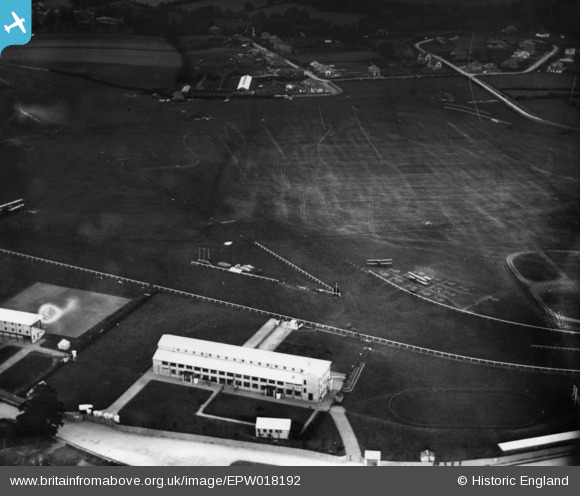
epw018192 ENGLAND (1927). Bournemouth Racecourse at Ensbury Park, Bournemouth, 1927. This image has been produced from a print.
© Copyright OpenStreetMap contributors and licensed by the OpenStreetMap Foundation. 2026. Cartography is licensed as CC BY-SA.
Details
| Title | [EPW018192] Bournemouth Racecourse at Ensbury Park, Bournemouth, 1927. This image has been produced from a print. |
| Reference | EPW018192 |
| Date | 7-June-1927 |
| Link | |
| Place name | BOURNEMOUTH |
| Parish | |
| District | |
| Country | ENGLAND |
| Easting / Northing | 408031, 95489 |
| Longitude / Latitude | -1.8861281645926, 50.758370601578 |
| National Grid Reference | SZ080955 |
Pins

Cyberbia |
Wednesday 22nd of August 2018 10:29:20 PM | |
|
Cyberbia |
Wednesday 22nd of August 2018 10:28:34 PM | |
|
Cyberbia |
Wednesday 22nd of August 2018 10:27:41 PM | |

Class31 |
Wednesday 14th of January 2015 11:28:43 AM | |
|
Class31 |
Wednesday 14th of January 2015 11:28:16 AM | |
|
Class31 |
Wednesday 14th of January 2015 11:27:51 AM | |
|
Class31 |
Wednesday 14th of January 2015 11:27:25 AM |
User Comment Contributions
Note the biplanes. Air Races were held at the Ensbury Racecourse in the 20s. |
Tim Hale |
Monday 8th of June 2015 01:37:06 PM |