
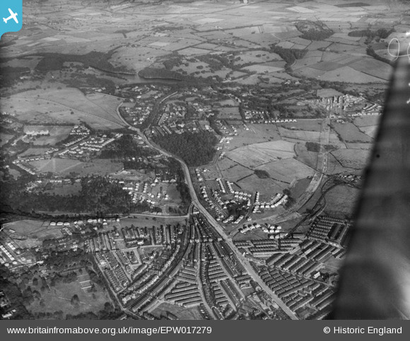
epw017279 ENGLAND (1926). Gipton Wood and environs, Leeds, from the south-west, 1926
© Copyright OpenStreetMap contributors and licensed by the OpenStreetMap Foundation. 2024. Cartography is licensed as CC BY-SA.
Details
| Title | [EPW017279] Gipton Wood and environs, Leeds, from the south-west, 1926 |
| Reference | EPW017279 |
| Date | October-1926 |
| Link | |
| Place name | LEEDS |
| Parish | |
| District | |
| Country | ENGLAND |
| Easting / Northing | 431917, 435909 |
| Longitude / Latitude | -1.5151464552268, 53.818266189901 |
| National Grid Reference | SE319359 |
Pins
 PCM |
Sunday 17th of March 2024 12:52:06 PM | |
Brick Collector |
Thursday 15th of June 2017 10:25:00 AM | |
Brick Collector |
Sunday 11th of October 2015 09:51:14 PM | |
Brick Collector |
Sunday 11th of October 2015 08:57:47 PM | |
Brick Collector |
Sunday 11th of October 2015 08:43:01 PM | |
Brick Collector |
Sunday 11th of October 2015 08:41:37 PM | |
Brick Collector |
Sunday 11th of October 2015 08:39:36 PM | |
Andrew |
Saturday 11th of October 2014 07:18:16 PM | |
Andrew |
Saturday 11th of October 2014 07:17:42 PM | |
Andrew |
Saturday 11th of October 2014 07:17:08 PM | |
Andrew |
Saturday 11th of October 2014 07:16:04 PM | |
Andrew |
Saturday 11th of October 2014 07:16:02 PM | |
Brick Collector |
Tuesday 15th of July 2014 09:00:14 PM | |
Brick Collector |
Wednesday 25th of June 2014 08:52:47 PM | |
Brick Collector |
Wednesday 25th of June 2014 08:48:12 PM | |
Brick Collector |
Sunday 23rd of February 2014 08:26:02 PM | |
Brick Collector |
Sunday 2nd of February 2014 10:10:13 PM | |
Brick Collector |
Sunday 2nd of February 2014 10:06:27 PM | |
Brick Collector |
Sunday 2nd of February 2014 10:05:27 PM | |
Brick Collector |
Sunday 2nd of February 2014 10:02:11 PM | |
Brick Collector |
Sunday 2nd of February 2014 10:01:19 PM | |
Brick Collector |
Sunday 2nd of February 2014 09:55:33 PM | |
Peter Slee |
Wednesday 27th of June 2012 09:52:13 PM | |
Peter Slee |
Wednesday 27th of June 2012 09:51:26 PM | |
Peter Slee |
Wednesday 27th of June 2012 09:45:58 PM | |
Peter Slee |
Wednesday 27th of June 2012 09:42:36 PM | |
Peter Slee |
Wednesday 27th of June 2012 09:40:18 PM | |
Peter Slee |
Wednesday 27th of June 2012 09:38:58 PM | |
Peter Slee |
Wednesday 27th of June 2012 09:37:52 PM | |
Peter Slee |
Wednesday 27th of June 2012 09:36:54 PM |
User Comment Contributions
Photo shows Roundhay Park Upper and Lower Lakes at top middle. Soldiers Field, still in existence, is just below the lakes, with Princess Avenue, lined by trees is seen prior to Trams running alongside it. Arrowhead shaped building in photo centre, was the old Astoria Dancing Hall situated alongside Wetherby Road. The early construction of Easterly Road, eventually to join up with Wetherby Road at Seacroft can be seen as a new cutting in the fields and woods, snaking away to the right. |
Peter Slee |
Tuesday 26th of June 2012 09:57:19 PM |