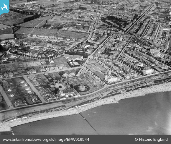
epw016544 ENGLAND (1926). Ellis Road, Martello Tower F and environs, Clacton-on-Sea, 1926
© Copyright OpenStreetMap contributors and licensed by the OpenStreetMap Foundation. 2025. Cartography is licensed as CC BY-SA.
Nearby Images (9)
Details
| Title | [EPW016544] Ellis Road, Martello Tower F and environs, Clacton-on-Sea, 1926 |
| Reference | EPW016544 |
| Date | August-1926 |
| Link | |
| Place name | CLACTON-ON-SEA |
| Parish | |
| District | |
| Country | ENGLAND |
| Easting / Northing | 617255, 214474 |
| Longitude / Latitude | 1.1503437791504, 51.786220411264 |
| National Grid Reference | TM173145 |
Pins
 Amiguru |
Sunday 12th of October 2014 05:50:53 PM | |
 Amiguru |
Sunday 12th of October 2014 05:40:38 PM | |
 Amiguru |
Friday 10th of October 2014 08:22:36 PM | |
 Amiguru |
Friday 10th of October 2014 08:21:53 PM | |
 Amiguru |
Friday 10th of October 2014 08:20:12 PM | |
 Amiguru |
Friday 10th of October 2014 08:16:27 PM | |
 Amiguru |
Friday 10th of October 2014 08:14:09 PM | |
 Amiguru |
Friday 10th of October 2014 08:11:43 PM | |
 Amiguru |
Friday 10th of October 2014 08:10:57 PM | |
 Davel |
Monday 2nd of June 2014 02:57:31 PM | |
Known as Martello Tower 'F' |
 Amiguru |
Friday 10th of October 2014 08:13:09 PM |


![[EPW016544] Ellis Road, Martello Tower F and environs, Clacton-on-Sea, 1926](http://britainfromabove.org.uk/sites/all/libraries/aerofilms-images/public/100x100/EPW/016/EPW016544.jpg)
![[EPW001870] View of Clacton-on-Sea, pier and Martello Tower, Clacton-on-Sea, 1920](http://britainfromabove.org.uk/sites/all/libraries/aerofilms-images/public/100x100/EPW/001/EPW001870.jpg)
![[EPW011621] Beatrice Road and environs, Clacton-On-Sea, 1924. This image has been produced from a copy-negative.](http://britainfromabove.org.uk/sites/all/libraries/aerofilms-images/public/100x100/EPW/011/EPW011621.jpg)
![[EPW049295] Freeland Road, Martello Tower No. 6 and the seafront, Clacton-On-Sea, 1935. This image has been produced from a copy-negative.](http://britainfromabove.org.uk/sites/all/libraries/aerofilms-images/public/100x100/EPW/049/EPW049295.jpg)
![[EPW039155] The Beaumont Hall Hotel, Clacton-on-Sea, 1932](http://britainfromabove.org.uk/sites/all/libraries/aerofilms-images/public/100x100/EPW/039/EPW039155.jpg)
![[EPW049143] Freeland Road and the town, Clacton-On-Sea, from the south-west, 1935. This image has been produced from a print.](http://britainfromabove.org.uk/sites/all/libraries/aerofilms-images/public/100x100/EPW/049/EPW049143.jpg)
![[EPW001994] General view of the town and pier, Clacton-on-Sea, 1920](http://britainfromabove.org.uk/sites/all/libraries/aerofilms-images/public/100x100/EPW/001/EPW001994.jpg)
![[EPW046895] The Pier and the town along the seafront, Clacton-on-Sea, 1935](http://britainfromabove.org.uk/sites/all/libraries/aerofilms-images/public/100x100/EPW/046/EPW046895.jpg)