
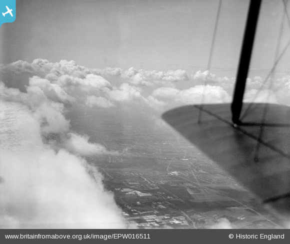
epw016511 ENGLAND (1926). An area of glasshouses at Enfield Highway, Enfield, from the north, 1926
© Copyright OpenStreetMap contributors and licensed by the OpenStreetMap Foundation. 2025. Cartography is licensed as CC BY-SA.
Details
| Title | [EPW016511] An area of glasshouses at Enfield Highway, Enfield, from the north, 1926 |
| Reference | EPW016511 |
| Date | August-1926 |
| Link | |
| Place name | ENFIELD |
| Parish | |
| District | |
| Country | ENGLAND |
| Easting / Northing | 535344, 196855 |
| Longitude / Latitude | -0.043293049785152, 51.653703875199 |
| National Grid Reference | TQ353969 |
Pins

Class31 |
Wednesday 11th of March 2015 08:19:43 AM | |

Ray Flack |
Saturday 23rd of November 2013 10:39:34 AM | |
|
Ray Flack |
Monday 18th of November 2013 10:42:14 AM | |
|
Ray Flack |
Monday 18th of November 2013 10:40:16 AM | |
|
Ray Flack |
Monday 18th of November 2013 09:46:29 AM | |
|
Ray Flack |
Monday 18th of November 2013 09:44:27 AM | |
|
Ray Flack |
Monday 18th of November 2013 09:41:48 AM | |
|
Ray Flack |
Monday 18th of November 2013 09:40:15 AM | |
|
Ray Flack |
Monday 18th of November 2013 09:34:55 AM | |
|
Ray Flack |
Monday 18th of November 2013 09:29:13 AM | |
|
Ray Flack |
Monday 18th of November 2013 09:23:54 AM | |
|
Ray Flack |
Monday 18th of November 2013 09:22:39 AM | |
|
Ray Flack |
Monday 18th of November 2013 09:20:46 AM | |
I found on a map circa 1750 that Caterhatch Road was called Pigots Lane. I believe it was a lane that was used to move cattle to and from grazing lands. |
Grey70 |
Wednesday 10th of September 2014 07:34:13 PM |
|
Ray Flack |
Monday 18th of November 2013 09:19:36 AM | |
|
Ray Flack |
Monday 18th of November 2013 09:13:28 AM | |
|
Ray Flack |
Monday 18th of November 2013 09:12:41 AM | |
|
Ray Flack |
Monday 18th of November 2013 09:08:25 AM | |
|
Ray Flack |
Monday 18th of November 2013 09:07:06 AM | |
|
Ray Flack |
Monday 18th of November 2013 09:06:02 AM | |
|
Ray Flack |
Monday 18th of November 2013 09:04:43 AM | |
|
Ray Flack |
Monday 18th of November 2013 08:59:22 AM | |
|
Ray Flack |
Monday 18th of November 2013 08:54:28 AM | |
|
Ray Flack |
Monday 18th of November 2013 08:52:54 AM | |
|
Ray Flack |
Monday 18th of November 2013 08:51:50 AM | |
|
Ray Flack |
Monday 18th of November 2013 08:49:13 AM | |
|
Ray Flack |
Monday 18th of November 2013 08:45:41 AM | |
|
Ray Flack |
Monday 18th of November 2013 08:44:12 AM | |
|
Ray Flack |
Monday 18th of November 2013 08:42:20 AM | |
|
Ray Flack |
Monday 18th of November 2013 08:41:20 AM | |
|
Ray Flack |
Monday 18th of November 2013 08:40:33 AM | |
|
Ray Flack |
Monday 18th of November 2013 08:38:32 AM | |
|
Ray Flack |
Monday 18th of November 2013 08:37:29 AM | |
|
Class31 |
Sunday 9th of June 2013 08:48:03 PM | |
|
Class31 |
Sunday 9th of June 2013 08:46:48 PM | |
|
Class31 |
Sunday 9th of June 2013 08:39:21 PM | |
|
Class31 |
Sunday 9th of June 2013 08:38:25 PM | |
|
Class31 |
Sunday 9th of June 2013 08:56:32 AM | |
|
Class31 |
Sunday 9th of June 2013 08:55:20 AM | |
|
Class31 |
Sunday 9th of June 2013 08:36:06 AM | |
|
Class31 |
Sunday 9th of June 2013 08:31:47 AM | |
|
Class31 |
Sunday 9th of June 2013 08:28:00 AM | |
|
Class31 |
Sunday 9th of June 2013 08:27:10 AM | |
|
Class31 |
Wednesday 9th of January 2013 08:40:02 PM | |
I now know this is Churchbury Station LNER. |
Class31 |
Sunday 9th of June 2013 08:40:49 AM |
Churchbury Station was renamed Southbury Station in 1960. |
Class31 |
Sunday 9th of June 2013 08:50:27 AM |

User Comment Contributions
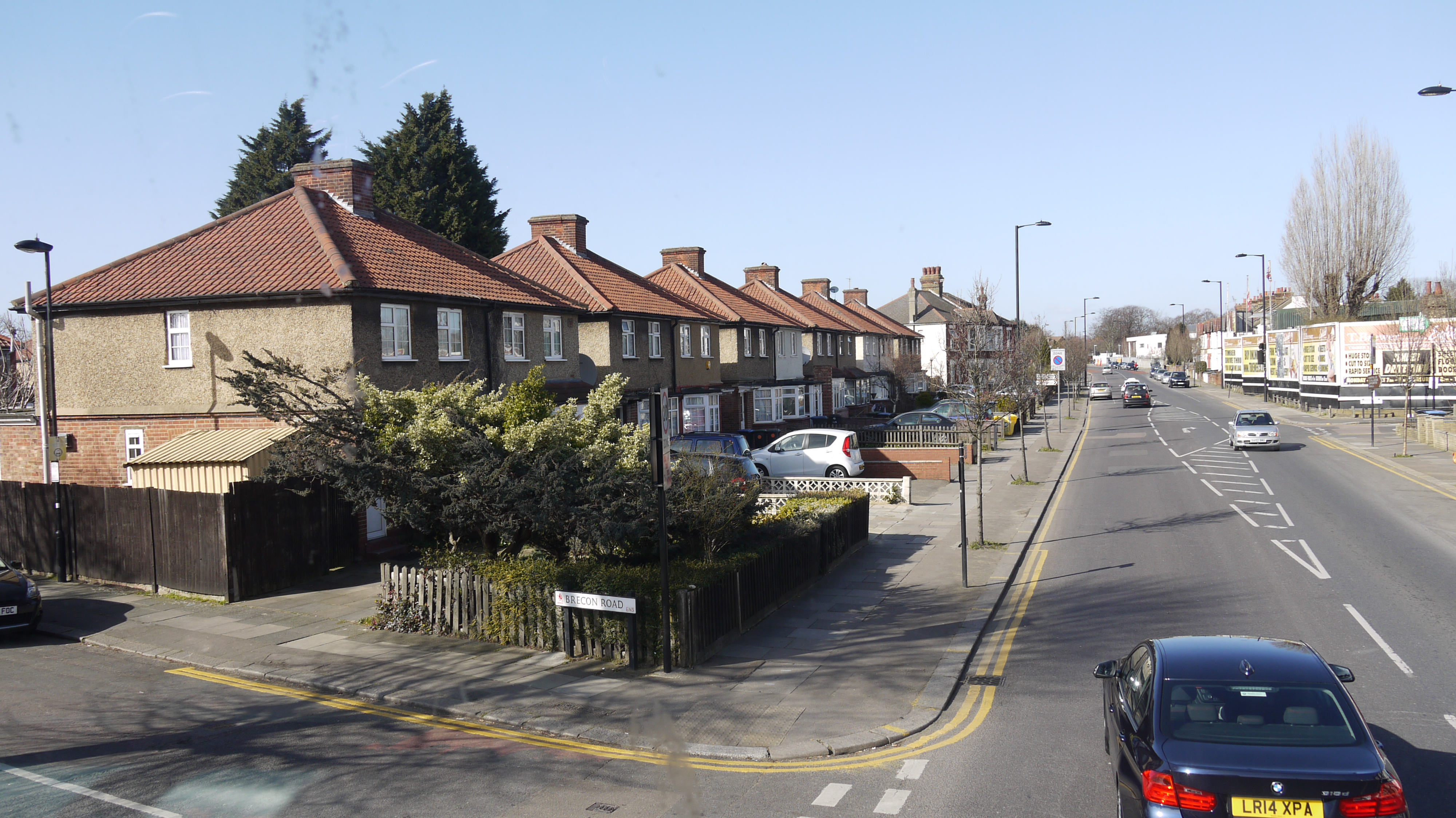
Hertford Road at Brecon Road, 10/03/2015 |
Class31 |
Monday 31st of August 2015 09:48:39 AM |

Durants Park looking east, 10/03/2015 |
Class31 |
Wednesday 11th of March 2015 08:14:14 AM |
I am confident that I have correctly located this photo whih was taken looking broadly south from above Enfield Highway. The clouds do an almost perfect job in obscuring the reservoirs on the River Lea which would be on the left of the photo. This is one of the original photos released in June 2012 which has finally been located. |
Class31 |
Tuesday 26th of November 2013 05:00:46 PM |
Hi Class31, Thanks for the location for this image; those glasshouses are very characteristic aren't they? We'll update the catalogue and post the new record here in due course. Yours, Katy Britain from Above Cataloguing Team Leader |
Katy Whitaker |
Tuesday 2nd of July 2013 11:19:13 AM |
Hi Class 31, Re photo:- EPW016511. I have looked long and hard at this photo and l think that you may have the wrong location. I agree that this road is similar to the "Enfield Highway", but a few details you put in don't seem to tally. 1st. There is no sign of "St, James Church" just South of Green Street (East of the Highway) that l also cannot see. 2nd. The railway runs at ground level from Cheshunt in the North, joining the line from Enfield Town at Bury Street. This line only crosses Three bridges:- Theobalds Grove Station, Turkey Street Station and Lincoln Rd. All other roads crossing this line go over the line, i.e. Bullsmoor Lane, Hoe Lane, Carterhatch Lane, Brick Lane, Tyberry Rd and Southbury Rd. 3rd. By 1926 the date of this photo the Enfield Highway was developed much more then this image is showing. Hope you don't mind me pointing these points out to you as l know just how much frustration some of these photos can cause. Best Regard Ray... |
Ray Flack |
Thursday 14th of November 2013 01:10:13 PM |
Hi Ray Flack Following your comments today I have had another look at this photograph as the last thing we want to do I identify it incorrectly. I have compared the photograph with the information shown on the 1:10560 Ordnance Survey map for the area as shown on the Old Maps website. I have used the Durants Park area as the basis for my comparison. On the map there are two large glasshouses at the south west side of Durants Park between the park and the Hertford Road. Similar glasshouses can be seen in the photo. Alongside these glasshouses are a group of smaller glasshouses which can also be seen in the Aerofilms photo. One of the most useful aids to identification are the roads and Hertford Road has the same line in the photo and on the map. I would ask you to take a look at the Old Maps website and see if you then agree with my interpretation of this photo. Thanks for your comments. |
Class31 |
Thursday 14th of November 2013 03:07:19 PM |
Hi again. Thank you for replying so quickly. Since your reply l have been to the Enfield Library and brought a 1913 survey map and spent two days placing the photo with the survey. I now believe that you are correct as to this photo and this is why, using Durance Park as a ref point:- Looking at the photo the two large greenhouses to the south of the park alongside the road you can see the south most of the two g/houses cutting away to a angle, this is also shown on the survey map. Next your ref points as to Anglesey Rd and Aberdare Rd. Yes 100%. although l beg to differ on your pointer on the "Bridge Abutment". Looking at the survey map it shows as a roadway running down a embankment to railway sidings. With this in mind look at the photo again, you can see that what looks like an abutment is in fact a triangular peace of ground between the roadway and the bridge. By blowing the photo up a little you can just make out Southbury Rd crossing the bridge with the station building on the south side of the road and the tunnel entrance on the north. Sorry for doubting you, l have lived in Enfield all my life and until l saw this survey map l never realised the amount of g/houses and nursery's in this area. Best regards Ray... |
Ray Flack |
Saturday 16th of November 2013 01:43:03 PM |
Hi Ray I'm glad that we are agreed on the location. You seem to have identified just about everywhere on this photo. I think that my bridge abutment comment was made very early on when we had nothing to go on. For many months we had no idea where this image had been taken. I shall request that Britain from Above includes a year on our comments so that we have a complete record otherwise the record is incomplete when we do not know which year the comment was made. I hope you can make it to the event at Swindon on Friday. I look forward to meeting as many friends as possible there. Thanks Class31 |
Class31 |
Tuesday 26th of November 2013 05:00:46 PM |
The main clue to locating this photo was the East and West Reservoirs which are near the top of the photo. These have been helpful in locating other photos and are a unique feature. |
Class31 |
Sunday 9th of June 2013 08:58:36 AM |
I think that I may be able to identify this photograph. Eureka |
Class31 |
Sunday 9th of June 2013 08:15:48 AM |
I just wish that I could get a lead on this one which has eluded everyone since the web site opened. There look to be lots of horticultural glass houses and a flat terrain. I would guess that this is an area west of London but with nothing much to base it on. Good luck everyone. |
Class31 |
Tuesday 11th of December 2012 08:06:55 PM |