
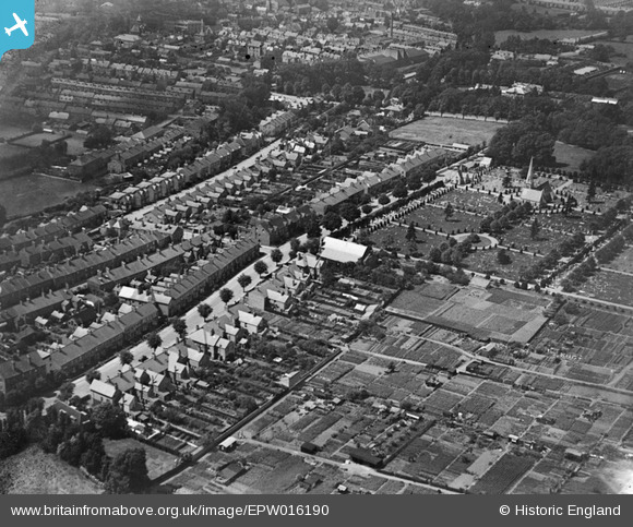
epw016190 ENGLAND (1926). Harrow Road and the cemetery, Grantham, 1926
© Copyright OpenStreetMap contributors and licensed by the OpenStreetMap Foundation. 2025. Cartography is licensed as CC BY-SA.
Details
| Title | [EPW016190] Harrow Road and the cemetery, Grantham, 1926 |
| Reference | EPW016190 |
| Date | July-1926 |
| Link | |
| Place name | GRANTHAM |
| Parish | |
| District | |
| Country | ENGLAND |
| Easting / Northing | 492101, 335399 |
| Longitude / Latitude | -0.63036721496656, 52.907800123378 |
| National Grid Reference | SK921354 |
Pins

Class31 |
Wednesday 10th of April 2013 09:40:20 AM | |
|
Class31 |
Wednesday 10th of April 2013 09:38:46 AM | |
|
Class31 |
Wednesday 10th of April 2013 09:38:11 AM | |
|
Class31 |
Wednesday 10th of April 2013 09:37:46 AM | |
|
Class31 |
Wednesday 10th of April 2013 09:36:50 AM | |
|
Class31 |
Wednesday 10th of April 2013 09:36:06 AM | |
|
Class31 |
Wednesday 10th of April 2013 09:35:11 AM | |
|
Class31 |
Wednesday 10th of April 2013 09:34:01 AM | |

Cabby |
Saturday 13th of October 2012 10:22:49 AM | |
|
Cabby |
Saturday 13th of October 2012 10:22:04 AM | |

manley |
Tuesday 26th of June 2012 07:56:49 PM | |
|
manley |
Tuesday 26th of June 2012 07:48:51 PM |
User Comment Contributions
This picture is listed under 'Harrow' as in Harrow Middlesex, when it should be listed under Grantham, Licolnshire. |
Sweet Pete |
Thursday 6th of August 2015 10:24:11 AM |
This is Harrowby Road, not Harrow Road |
mee |
Tuesday 27th of August 2013 04:33:33 PM |
Believe that to be HARROWBY LANE in Grantham, not Harrow Road? |
bigwinn |
Wednesday 10th of April 2013 09:30:39 AM |
The title of this needs to be amended to Harrowby Road. |
Class31 |
Wednesday 10th of April 2013 09:30:39 AM |
This is indeed Harrowby Road,Grantham.The large cemetary has two chapels. One is for the Church of England and the other is for the Nonconformists. At the cemetary entrance is a lodge.The road running almost parallel with Harrowby Road is Dudley Road. |
Cabby |
Monday 16th of July 2012 08:30:11 PM |
Sorry, this image is being displayed in the wrong county |
L. E. Watson |
Tuesday 26th of June 2012 08:37:57 AM |