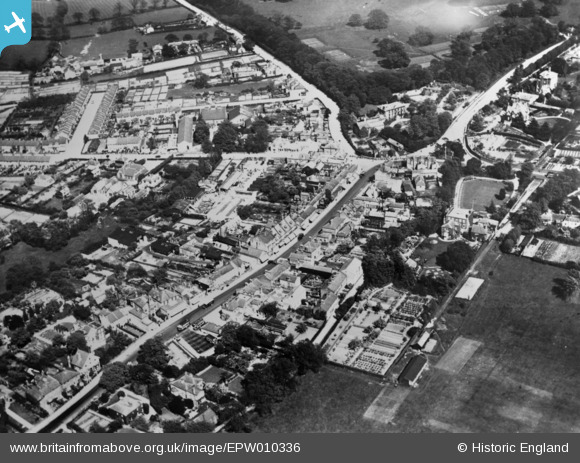
epw010336 ENGLAND (1924). Chase Side and environs, Southgate, 1924. This image has been produced from a copy-negative.

© Copyright OpenStreetMap contributors and licensed by the OpenStreetMap Foundation. 2025. Cartography is licensed as CC BY-SA.

Details

Title [EPW010336] Chase Side and environs, Southgate, 1924. This image has been produced from a copy-negative.
Reference EPW010336
Date April-1924
Link
Place name SOUTHGATE
Parish
District
Country ENGLAND
Easting / Northing 529585, 194330
Longitude / Latitude -0.12743892116006, 51.63236780122
National Grid Reference TQ296943

Pins

Methodist Chapel, shown on 1894-95 maps, in use until 1929. Subsequently used as a Sunday schoolroom.

Peter
Monday 13th of February 2017 08:27:11 PM
Alpine House: the distinctive gabled roof with finials can be identified in many old photographs. H W Newby pointed out that the gabled roof (and so perhaps much of the building) survived behind the modern shop front. It seems to have gone now in redevelopment for Pizza Express.

Peter
Tuesday 8th of March 2016 11:38:20 AM
Ice pond. In the latter half of the 1800s Abraham Simmons dammed Houndsden Gutter to form ponds from which, in winter, he collected ice for storage in ice wells. This he would sell to London fishmongers, hence the nearby Fishmonger's Arms. In the attached picture can be seen Ivy Stores and houses in Chase Road.

Peter
Tuesday 8th of March 2016 11:34:15 AM
Trees in leaf and the sun shining, but the first half of April 1924 was cold and snow fell on six separate days. On this day, I think, there had been a light fall of snow overnight which had frozen on colder surfaces. Only on Chase Side and the High Street had motor vehicles made their mark.

Peter
Monday 7th of March 2016 03:30:51 PM
Entrance to Grovelands, a hospital since 1916.

Peter
Thursday 3rd of March 2016 09:10:16 PM

Peter
Thursday 3rd of March 2016 08:37:30 PM
Queen Elizabeth's Lodge: From before 1850 an academy for young men destined for military or public service. From 1904, when it gained its name, the building housed a girls preparatory school. In 1913 it became a Church Army reformatory for girls.

Peter
Thursday 3rd of March 2016 08:35:34 PM
Crocodile of children crossing from Chase Road to the High Street.

Peter
Tuesday 1st of March 2016 08:04:29 PM

Peter
Tuesday 1st of March 2016 08:00:47 PM
In 1884 the Baptists built this corrugated iron chapel. When they moved to Chase Side in 1894 it was retained for Sunday School.

Peter
Tuesday 1st of March 2016 07:43:42 PM
High Street. Bunkers the wheelwrights were replaced in 1897 by a row of four shops (see attached picture). The wooden cottages had gone when the aerial picture was taken.

Peter
Monday 29th of February 2016 12:41:25 PM
Church of England schools: Boys from 1887, Infants from 1895.

Peter
Sunday 28th of February 2016 04:19:34 PM
College House boarding school for 45 boys. Active before 1828 until about 1895. It may have been associated with the nearby Independent Chapel.

Peter
Sunday 28th of February 2016 04:06:14 PM
Southgate Smithy, the corner of the roof can be seen in the aerial photo. The smithy had been on this site for some 300 years. The attached photo was taken in 1932 when it was about to be demolished for the underground railway. The Lawns can be seen beyond.

Peter
Thursday 25th of February 2016 05:48:33 PM
White Hart, Chase Road.

Peter
Thursday 25th of February 2016 05:23:40 PM
Church, on OS maps 1913 and 1937. Denomination?

Peter
Thursday 25th of February 2016 04:52:51 PM
This would appear to be the site of the Methodist church, built around 1929. So it may be an earlier chapel of theirs, although I have come across a comment that they originally met in Chase Side.

John W
Saturday 9th of July 2016 03:01:34 PM
I see from the SDCT site that it was St Thomas's church, a chapel of ease for St Paul's, Winchmore Hill. A prefabricated corrugated iron building, it was in use 1905-35. In WW2 it was used as a gas cleansing station, happily never needed.

Peter
Monday 13th of February 2017 08:03:25 PM
Baptist Chapel. The site of a building erected in 1809 by a society for the promotion of Sunday Schools for children. In 1815 this was taken over by the Independents who, in the 1860s, rebuilt it with the square tower and steeple we see here. It was sold to the Baptists in 1894.

Peter
Thursday 25th of February 2016 04:27:04 PM
The Crown, erected 1895 to replace a much older building. To the rear of the car park can be seen the formal garden. With my parents there one summer evening before the War I observed, as a child would, that the paths were edged with beer bottles set at an angle.

Peter
Thursday 25th of February 2016 03:20:44 PM
Crown Lane followed the edge of Enfield Chase, which was also the boundary between Middlesex and Hertfordshire. Early buildings on the north side of the lane, including the Crown Inn, were an encroachment on the chase. Travellers too were inclined to cut across the corner of the chase rather than follow Crown Lane. Some of the cottages visible in the aerial picture still survive.

Peter
Thursday 25th of February 2016 11:14:59 AM
Fishmonger's Arms, Winchmore Hill Road.

Peter
Thursday 25th of February 2016 10:57:27 AM
Houndsden Gutter follows the hedge line here. It rises near to the junction of Bramley Road and Chase Side, goes under Avenue Road and Chase Road, and flows off the top of this picture to join the Salmon Brook at Grange Park.

Peter
Wednesday 24th of February 2016 09:10:57 PM
Frederick Lee, Post Office and grocery store.

Peter
Tuesday 23rd of February 2016 04:31:58 PM
Future Site of Southgate station (Circa 1933)On The Piccadily Line

Macmartyn
Friday 28th of November 2014 05:05:38 PM