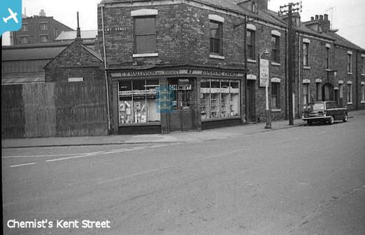
epw009396 ENGLAND (1923). The Kingston Works and environs, Kingston upon Hull, 1923

© Copyright OpenStreetMap contributors and licensed by the OpenStreetMap Foundation. 2024. Cartography is licensed as CC BY-SA.
Nearby Images (8)
EPW009396

EPW034651

EPW034642

EPW034643

EPW034645

EPW034644

EPW034653

EPW034646

Details
| Title | [EPW009396] The Kingston Works and environs, Kingston upon Hull, 1923 |
| Reference | EPW009396 |
| Date | 1923 |
| Link | |
| Place name | KINGSTON UPON HULL |
| Parish | |
| District | |
| Country | ENGLAND |
| Easting / Northing | 510742, 429893 |
| Longitude / Latitude | -0.32023669741411, 53.75339825911 |
| National Grid Reference | TA107299 |
Pins
 Andy |
Monday 28th of October 2019 08:19:15 PM | |
John Wass |
Tuesday 21st of April 2015 04:03:04 PM | |
John Wass |
Tuesday 21st of April 2015 04:01:46 PM | |
Sharmo |
Saturday 21st of February 2015 08:59:47 PM | |
Sharmo |
Saturday 21st of February 2015 08:56:53 PM | |
Sharmo |
Saturday 21st of February 2015 08:54:11 PM | |
 |
Sharmo |
Saturday 21st of February 2015 08:48:05 PM |
Sharmo |
Saturday 21st of February 2015 06:07:15 PM | |
Sharmo |
Saturday 21st of February 2015 06:05:36 PM | |
 |
Sharmo |
Saturday 21st of February 2015 05:59:29 PM |
Sharmo |
Saturday 21st of February 2015 05:48:06 PM | |
Sharmo |
Saturday 21st of February 2015 05:42:26 PM | |
Sharmo |
Saturday 21st of February 2015 10:06:05 AM | |
Sharmo |
Saturday 21st of February 2015 09:54:15 AM | |
Sharmo |
Saturday 21st of February 2015 09:50:38 AM | |
CartoonHead |
Sunday 8th of February 2015 04:01:51 PM | |
John Wass |
Wednesday 18th of June 2014 08:46:49 PM | |
John Wass |
Wednesday 18th of June 2014 08:44:48 PM |