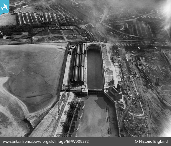
epw009272 ENGLAND (1923). The Gladstone Graving Dock, Bootle, 1923
© Copyright OpenStreetMap contributors and licensed by the OpenStreetMap Foundation. 2024. Cartography is licensed as CC BY-SA.
Details
| Title | [EPW009272] The Gladstone Graving Dock, Bootle, 1923 |
| Reference | EPW009272 |
| Date | 1923 |
| Link | |
| Place name | BOOTLE |
| Parish | |
| District | |
| Country | ENGLAND |
| Easting / Northing | 332598, 396133 |
| Longitude / Latitude | -3.0152186079438, 53.45737664464 |
| National Grid Reference | SJ326961 |
Pins
 Ronnie |
Wednesday 14th of September 2016 11:40:54 AM | |
 gBr |
Monday 21st of September 2015 07:39:36 PM | |
 gBr |
Monday 21st of September 2015 07:37:03 PM | |
 gBr |
Monday 21st of September 2015 07:36:16 PM | |
 gBr |
Monday 21st of September 2015 07:34:54 PM | |
 TomRobin |
Sunday 5th of May 2013 11:20:41 AM | |
 TomRobin |
Sunday 5th of May 2013 11:17:52 AM | |
 TomRobin |
Sunday 5th of May 2013 11:17:31 AM |
User Comment Contributions
This is the Graving dock at Bootle, Liverpool. To the right is the Gladstone dock seemingly under construction. The overhead railway turning inland. |
 TomRobin |
Monday 1st of July 2013 01:13:18 PM |
Hi TomRobin, Thank you for the identification - we'll update the catalogue with your correct data, and post the new record here in due course. Yours, Katy Britain from Above Cataloguing Team Leader |
Katy Whitaker |
Monday 1st of July 2013 01:13:18 PM |
A dry dock, so presumably one of the big ship building towns |
 TomRobin |
Friday 21st of June 2013 06:39:52 PM |
Dry dock suggests ship repair, rather then ship building. |
 Maurice |
Friday 21st of June 2013 06:39:52 PM |


![[EPW009272] The Gladstone Graving Dock, Bootle, 1923](http://britainfromabove.org.uk/sites/all/libraries/aerofilms-images/public/100x100/EPW/009/EPW009272.jpg)
![[EPW053309] Gladstone Dock and environs, Bootle, 1937. This image has been produced from a print.](http://britainfromabove.org.uk/sites/all/libraries/aerofilms-images/public/100x100/EPW/053/EPW053309.jpg)
![[EPW050661] The Port of Liverpool Docks alongside the River Mersey, Bootle, from the north, 1936](http://britainfromabove.org.uk/sites/all/libraries/aerofilms-images/public/100x100/EPW/050/EPW050661.jpg)
![[EPW018873] Gladstone Dock, Bootle, 1927. This image has been produced from a print.](http://britainfromabove.org.uk/sites/all/libraries/aerofilms-images/public/100x100/EPW/018/EPW018873.jpg)