
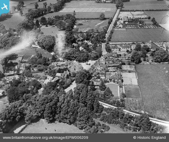
epw006209 ENGLAND (1921). The village centre, Farnham Royal, 1921. This image has been produced from a damaged negative.
© Copyright OpenStreetMap contributors and licensed by the OpenStreetMap Foundation. 2025. Cartography is licensed as CC BY-SA.
Details
| Title | [EPW006209] The village centre, Farnham Royal, 1921. This image has been produced from a damaged negative. |
| Reference | EPW006209 |
| Date | April-1921 |
| Link | |
| Place name | FARNHAM ROYAL |
| Parish | FARNHAM ROYAL |
| District | |
| Country | ENGLAND |
| Easting / Northing | 495987, 182929 |
| Longitude / Latitude | -0.61588346446217, 51.536613719014 |
| National Grid Reference | SU960829 |
Pins

Doc |
Tuesday 28th of May 2024 09:35:19 AM | |
|
payitforwardeddie |
Wednesday 29th of May 2013 05:12:39 AM | |
|
USTigger |
Saturday 1st of September 2012 08:08:15 AM | |
|
USTigger |
Saturday 1st of September 2012 07:51:41 AM | |
I think this marker is intended for CORK TREE HOUSE - a large pre-war Rectory. In the 1960's it was demolished and Rectory Close was slotted into its grounds, plus a new purpose built Rectory, [this in turn, has become a private house] and Church Hall was built on two corner plots of the Close. |
Verdot |
Monday 26th of August 2013 07:38:54 PM |
|
USTigger |
Saturday 1st of September 2012 07:41:20 AM | |
|
USTigger |
Saturday 1st of September 2012 07:19:17 AM | |
|
dave43 |
Friday 3rd of August 2012 06:07:48 PM | |
|
dave43 |
Friday 3rd of August 2012 06:07:08 PM | |
|
Eton Slaphead |
Monday 9th of July 2012 10:00:17 PM | |
|
EastMarple1 |
Saturday 30th of June 2012 09:57:10 AM | |
Although, trees hide the house I would say this Farnham Royal Cottage and Field Cottage. In the Victorian period it was lived in by The Hon. Elizabeth Montaque and then Lady Wellesley, after her husband Queen Victoria's Chaplain died. Royalty visited them here on several occasions. |
Verdot |
Friday 23rd of August 2013 02:34:48 AM |
|
EastMarple1 |
Saturday 30th of June 2012 09:54:53 AM | |
|
BigglesH |
Tuesday 26th of June 2012 10:55:50 PM | |
|
BigglesH |
Tuesday 26th of June 2012 10:42:19 PM | |
This still exists but has been moved to the left (in the photograph) clear on the road. A mini roundabout is in its place. |
USTigger |
Saturday 1st of September 2012 07:45:06 AM |
Isn't this the Farnham Royal Pump? |
Pauline |
Friday 14th of June 2013 04:53:53 PM |
Yes, this was the central position of the attractive tiled canopied village pump until 1972. Firstly it was put in storage in Slough and then rebuilt in Farnham Park Playing Field. It is now located south west only yards away, on the Green, near the Dukes Head. It was moved and rebuilt in April 1994 mostly from the original materials. The pumping mechanism, although not working, was bolted back in position on its central post. The village was overjoyed to welcome it back and it now sits happily with the recent village sign and the flag pole. |
Verdot |
Monday 26th of August 2013 07:09:54 PM |
User Comment Contributions
This is the Farnham Royal Pump thats has been moved to a nearby housing area. It did actually have an old pump inside it at one time I seem to remember but its not there anymore. |
cjo1964 |
Saturday 15th of June 2013 02:16:53 PM |
Thanks to everyone who suggested Farnham Royal, that's spot-on. We can update the catalogue and the correct location will appear here in due course. Great job. Yours, Katy Britain from Above Cataloging Team Leader |
Katy Whitaker |
Tuesday 23rd of October 2012 01:15:46 PM |
Without doubt the Pump at Farnham Royal |
PJL |
Saturday 20th of October 2012 06:11:03 AM |
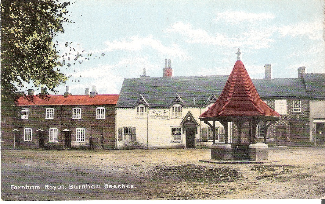
old Friths postcard |
dave43 |
Friday 3rd of August 2012 08:50:17 PM |
When first looking at a modern aerial view I thought this could not be Fareham Royal, but with a closer look at the geometry of the road junctions it is a perfect match. It would appear that about half the original buildings have disappeared and many new one have been built. The unfortunate well or butter cross (unlikely to be a bus shelter in the middle of the road) clearly did not coincide with the centre of the roundabout and so got swept away. The gable end to the right (east) of the shelter remains and is now painted white or cream. |

Maurice |
Friday 3rd of August 2012 05:27:57 PM |
Yes, Farnham Royal, I'm surprised most the old buildings have gone, quite a posh area, our teachers (Wm Penn County Secondary, nothing posh!)used to drink at The Jolly Butcher, Can I identify it? |
dave43 |
Friday 3rd of August 2012 05:27:57 PM |
That looks like a village well in the centre but I can't find it on Images of England so I suspect it's no longer standing. |

limbrix |
Wednesday 1st of August 2012 10:25:13 PM |
might be Farnham Royal Pump will have a look |
dave43 |
Wednesday 1st of August 2012 10:25:13 PM |