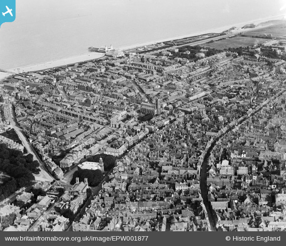
epw001877 ENGLAND (1920). General view of Great Yarmouth and St Spyridon's Church towards the Wellington Pier and Nelson Gardens, Great Yarmouth, 1920
© Copyright OpenStreetMap contributors and licensed by the OpenStreetMap Foundation. 2024. Cartography is licensed as CC BY-SA.
Details
| Title | [EPW001877] General view of Great Yarmouth and St Spyridon's Church towards the Wellington Pier and Nelson Gardens, Great Yarmouth, 1920 |
| Reference | EPW001877 |
| Date | June-1920 |
| Link | |
| Place name | GREAT YARMOUTH |
| Parish | |
| District | |
| Country | ENGLAND |
| Easting / Northing | 652726, 307115 |
| Longitude / Latitude | 1.7327019905828, 52.602570042799 |
| National Grid Reference | TG527071 |
Pins
 Bill_Gensheet |
Sunday 17th of June 2018 03:56:57 AM | |
 David960 |
Sunday 5th of February 2017 11:22:57 AM | |
 David960 |
Sunday 5th of February 2017 11:22:38 AM | |
 c.c |
Sunday 25th of August 2013 11:46:16 AM | |
 Alan McFaden |
Monday 22nd of July 2013 09:50:26 AM | |
 Alan McFaden |
Monday 22nd of July 2013 09:46:59 AM | |
 Alan McFaden |
Monday 22nd of July 2013 09:44:53 AM | |
At the time the picture was taken it was actually St Peters C of E. |
 Philip Gallagher |
Tuesday 23rd of June 2020 04:37:11 PM |
At the time the picture was taken it was actually St Peters C of E. |
 Philip Gallagher |
Tuesday 23rd of June 2020 04:37:12 PM |
User Comment Contributions
When this picture was taken St Spyridons Church was called St Peters Church. This church became the main church in Gt Yarmouth after the Parish Church was bombed during WW2. The Cypriot community in Gt Yarmouth took over St Peters church in the 1970 s and renamed it St Spyridons .The church among the trees in the forground is St georges , still standing and used as a theatre. |
 pebble |
Thursday 9th of May 2013 05:03:13 PM |


![[EPW001877] General view of Great Yarmouth and St Spyridon's Church towards the Wellington Pier and Nelson Gardens, Great Yarmouth, 1920](http://britainfromabove.org.uk/sites/all/libraries/aerofilms-images/public/100x100/EPW/001/EPW001877.jpg)
![[EAW052974] Middlegate and environs, Great Yarmouth, 1953](http://britainfromabove.org.uk/sites/all/libraries/aerofilms-images/public/100x100/EAW/052/EAW052974.jpg)
