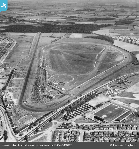
eaw049620 ENGLAND (1953). Doncaster, crowds at the racecourse, 1953
© Copyright OpenStreetMap contributors and licensed by the OpenStreetMap Foundation. 2025. Cartography is licensed as CC BY-SA.
Nearby Images (6)
Details
| Title | [EAW049620] Doncaster, crowds at the racecourse, 1953 |
| Reference | EAW049620 |
| Date | 18-May-1953 |
| Link | |
| Place name | DONCASTER |
| Parish | |
| District | |
| Country | ENGLAND |
| Easting / Northing | 459803, 402902 |
| Longitude / Latitude | -1.0979319967304, 53.519136496874 |
| National Grid Reference | SE598029 |
Pins
 Chris Kolonko |
Tuesday 12th of September 2017 09:44:53 PM | |
 Billy Turner |
Monday 30th of November 2015 06:30:20 PM |


![[EAW049620] Doncaster, crowds at the racecourse, 1953](http://britainfromabove.org.uk/sites/all/libraries/aerofilms-images/public/100x100/EAW/049/EAW049620.jpg)
![[EAW049619] Doncaster, crowds at the racecourse, from the south-east, 1953](http://britainfromabove.org.uk/sites/all/libraries/aerofilms-images/public/100x100/EAW/049/EAW049619.jpg)
![[EAW049622] Doncaster, crowds at the racecourse, 1953](http://britainfromabove.org.uk/sites/all/libraries/aerofilms-images/public/100x100/EAW/049/EAW049622.jpg)
![[EPW049248] Doncaster, Doncaster Racecourse on the day of the St Leger, 1935](http://britainfromabove.org.uk/sites/all/libraries/aerofilms-images/public/100x100/EPW/049/EPW049248.jpg)
![[EAW049621] Doncaster, crowds at the racecourse, 1953](http://britainfromabove.org.uk/sites/all/libraries/aerofilms-images/public/100x100/EAW/049/EAW049621.jpg)
![[EPW016988] Doncaster Racecourse Fourth Stand and the home straight on race day, Doncaster, 1926](http://britainfromabove.org.uk/sites/all/libraries/aerofilms-images/public/100x100/EPW/016/EPW016988.jpg)
