
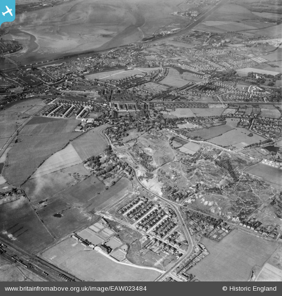
eaw023484 ENGLAND (1949). Runcorn Hill and the town, Runcorn, from the south-west, 1949
© Copyright OpenStreetMap contributors and licensed by the OpenStreetMap Foundation. 2026. Cartography is licensed as CC BY-SA.
Nearby Images (2)
EAW023484

EAW016790

Details
| Title | [EAW023484] Runcorn Hill and the town, Runcorn, from the south-west, 1949 |
| Reference | EAW023484 |
| Date | 26-May-1949 |
| Link | |
| Place name | RUNCORN |
| Parish | |
| District | |
| Country | ENGLAND |
| Easting / Northing | 350453, 381713 |
| Longitude / Latitude | -2.7440493635535, 53.329739559363 |
| National Grid Reference | SJ505817 |
Pins

HAP_Weston |
Friday 6th of June 2025 02:36:30 PM | |
|
HAP_Weston |
Friday 6th of June 2025 02:35:31 PM | |
|
HAP_Weston |
Friday 6th of June 2025 02:32:26 PM | |
|
HAP_Weston |
Friday 6th of June 2025 02:29:46 PM | |
|
HAP_Weston |
Friday 6th of June 2025 02:26:59 PM | |
|
HAP_Weston |
Friday 6th of June 2025 02:25:33 PM | |
|
HAP_Weston |
Friday 6th of June 2025 02:24:51 PM | |
|
HAP_Weston |
Friday 6th of June 2025 02:24:30 PM | |
|
HAP_Weston |
Friday 6th of June 2025 02:24:07 PM | |
|
HAP_Weston |
Friday 6th of June 2025 02:23:28 PM | |
|
HAP_Weston |
Friday 6th of June 2025 02:22:40 PM | |
|
HAP_Weston |
Friday 6th of June 2025 02:21:34 PM | |
|
HAP_Weston |
Friday 6th of June 2025 02:20:36 PM | |
|
HAP_Weston |
Friday 6th of June 2025 02:19:52 PM | |
|
HAP_Weston |
Friday 6th of June 2025 02:19:18 PM | |
|
HAP_Weston |
Friday 6th of June 2025 02:18:43 PM | |
|
HAP_Weston |
Friday 6th of June 2025 02:17:30 PM | |
|
Bottom Yard |
Sunday 30th of March 2025 04:00:15 PM | |
|
Steve |
Saturday 14th of November 2020 11:55:37 PM | |
|
Bottom Yard |
Monday 4th of February 2019 06:55:57 PM | |
|
Bottom Yard |
Thursday 27th of December 2018 07:11:05 PM | |
|
Bottom Yard |
Thursday 27th of December 2018 07:03:18 PM | |
|
Bottom Yard |
Thursday 27th of December 2018 06:58:27 PM | |
|
Bottom Yard |
Thursday 27th of December 2018 06:57:20 PM | |
|
Bottom Yard |
Thursday 27th of December 2018 06:53:34 PM | |
|
Bottom Yard |
Thursday 27th of December 2018 06:52:32 PM | |
|
Bottom Yard |
Thursday 27th of December 2018 06:49:03 PM | |
|
Jamie |
Thursday 21st of May 2015 06:33:02 PM | |
|
Jamie |
Thursday 21st of May 2015 06:31:13 PM | |
|
Jamie |
Thursday 21st of May 2015 06:28:38 PM | |
|
Jamie |
Thursday 21st of May 2015 06:27:46 PM | |
|
delveen_house |
Friday 25th of April 2014 07:11:45 PM | |
|
Phil |
Thursday 10th of April 2014 07:20:40 PM |