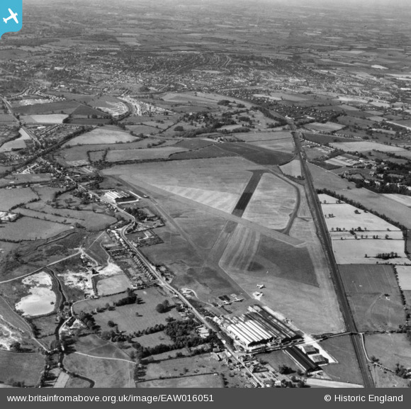
eaw016051 ENGLAND (1948). Radlett Aerodrome, Frogmore, 1948. This image has been produced from a print.

© Copyright OpenStreetMap contributors and licensed by the OpenStreetMap Foundation. 2024. Cartography is licensed as CC BY-SA.

Details

Title [EAW016051] Radlett Aerodrome, Frogmore, 1948. This image has been produced from a print.
Reference EAW016051
Date 19-May-1948
Link
Place name FROGMORE
Parish ST. STEPHEN
District
Country ENGLAND
Easting / Northing 515478, 203638
Longitude / Latitude -0.32811374481756, 51.71910522577
National Grid Reference TL155036

Pins

The main runway was extended around 1952 with the introduction of the victor V bomber.

paul
Tuesday 15th of February 2022 12:58:26 PM
Siding serving Napsbury Hospital, the northern-most buildings of which can be seen.

John W
Sunday 26th of January 2020 10:06:56 PM
The Red Cow Public House

Tinytroll
Thursday 16th of November 2017 02:44:49 PM
Part Street Cricket Pitch

Tinytroll
Thursday 16th of November 2017 02:43:10 PM
The former A5, Watling Street, now the A5183.

John W
Monday 12th of December 2016 05:34:27 PM
Centre of St Albans

John W
Monday 12th of December 2016 05:32:33 PM
St Albans Abbey

John W
Monday 12th of December 2016 05:31:23 PM
London Road station on the Great Northern, later LNER, branch line from Hatfield to St Albans, where it joined with the LNWR branch line; opened in 1865. The branch from Hatfield closed to passengers in September 1951, and completely to goods in 1968. By 1986 the line had been converted to a footpath and cycleway called 'The Alban Way'.

John W
Monday 12th of December 2016 05:30:41 PM
LNWR branch line from Watford Junction to St Albans Abbey station - still in use, although a suggestion has been made that it should be turned into a 'busway'.

John W
Monday 12th of December 2016 05:16:56 PM
Remaining traces of the line linking the LNWR Watford-St Albans Abbey branch to bring in materials for the construction of the Midland Railway line in the 1860s. Closed shortly after the MR line was completed, and never used for passenger trains.

John W
Monday 12th of December 2016 05:15:03 PM
Remaining traces of the line linking to the LNWR Watford-St Albans Abbey branch to bring in materials for the construction of the Midland Railway line in the 1860s. Closed shortly after the MR line was completed, and never used for passenger trains.

John W
Monday 12th of December 2016 05:14:07 PM
Railway line curving away to reach St Albans City station - the Midland Railway was originally planning to go in a straighter line further from the St Albans city centre, but was persuaded by the 'city Fathers' to divert to a position closer to the city centre than the MR's original plans.

John W
Monday 12th of December 2016 05:07:24 PM
Napsbury Signal box - remained in use until December 1979, and demolished soon after. The next box down the line, St Albans South, has been preserved and is regularly open to the public - see www.sigbox.co.uk.

John W
Monday 12th of December 2016 05:02:31 PM
Napsbury Lane bridge

John W
Monday 12th of December 2016 05:00:10 PM
North Orbital Road, previously the A405, now the A414.

John W
Monday 12th of December 2016 04:59:29 PM
Napsbury Station, opened 1905 to serve the nearby Middlesex Mental Hospital; the station was closed in 1959 when local services were taken over by DMUs from steam-hauled services. There was only an island platform serving the slow lines.

John W
Monday 12th of December 2016 04:58:44 PM
Midland "London Extension" railway, built 1868.

John W
Monday 12th of December 2016 04:55:04 PM
Moormill farm, (2014 A Beefeater Pub)

Tinytroll
Thursday 15th of January 2015 01:40:16 PM
Site of a USAAF B-26 Marauder crash in June 1944.The site is now under the M25 motorway

pffoto
Tuesday 2nd of September 2014 09:16:50 PM
Handley Page Hastings aircraft

pffoto
Tuesday 2nd of September 2014 09:14:14 PM
Handley Page Hastings aircraft

pffoto
Tuesday 2nd of September 2014 09:13:13 PM
The Handley Page"Radlett" factory constructed early 1930`s.Handley Page produced aircaraft on this site from 1930 to 1971, including the HP Harrow,HP42,Hampden, Halifax, Hermes,Hastings ,Victor and Jetstream. Runways removed now the land has been used for gravel extraction,the M25 bisects the airfield east to west. Currently (2014) the site is proposed as a major freight terminal,and if it goes ahead the HP airfield will disappear forever

pffoto
Tuesday 2nd of September 2014 09:11:54 PM
The later period Park Street hangars , constructed WW2, now demolished and is a housing estate with Handley Page names

pffoto
Tuesday 2nd of September 2014 09:03:49 PM

User Comment Contributions

This airfield is the centre of a controversial planning decision, by central government, to allow the construction of a 'Railfreight Terminal' connected to the Midland Main line, but without a connection to the nearby M25.

John W
Monday 12th of December 2016 05:10:07 PM