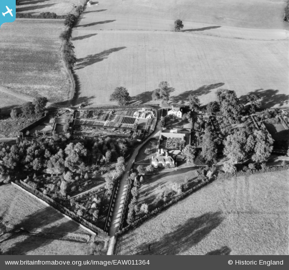
eaw011364 ENGLAND (1947). Tewin Mill House, Tewin, 1947
© Copyright OpenStreetMap contributors and licensed by the OpenStreetMap Foundation. 2024. Cartography is licensed as CC BY-SA.
Nearby Images (9)
Details
| Title | [EAW011364] Tewin Mill House, Tewin, 1947 |
| Reference | EAW011364 |
| Date | 1-October-1947 |
| Link | |
| Place name | TEWIN |
| Parish | TEWIN |
| District | |
| Country | ENGLAND |
| Easting / Northing | 527168, 213769 |
| Longitude / Latitude | -0.15524788138983, 51.807627884655 |
| National Grid Reference | TL272138 |
Pins
Be the first to add a comment to this image!


![[EAW011364] Tewin Mill House, Tewin, 1947](http://britainfromabove.org.uk/sites/all/libraries/aerofilms-images/public/100x100/EAW/011/EAW011364.jpg)
![[EAW011357] Tewin Mill House, Tewin, 1947](http://britainfromabove.org.uk/sites/all/libraries/aerofilms-images/public/100x100/EAW/011/EAW011357.jpg)
![[EAW011363] Tewin Mill House, Tewin, 1947](http://britainfromabove.org.uk/sites/all/libraries/aerofilms-images/public/100x100/EAW/011/EAW011363.jpg)
![[EAW011359] Tewin Mill House, Tewin, 1947](http://britainfromabove.org.uk/sites/all/libraries/aerofilms-images/public/100x100/EAW/011/EAW011359.jpg)
![[EAW011365] Tewin Mill House, Tewin, 1947](http://britainfromabove.org.uk/sites/all/libraries/aerofilms-images/public/100x100/EAW/011/EAW011365.jpg)
![[EAW011358] Tewin Mill House, Tewin, 1947](http://britainfromabove.org.uk/sites/all/libraries/aerofilms-images/public/100x100/EAW/011/EAW011358.jpg)
![[EAW011360] Tewin Mill House, Tewin, 1947](http://britainfromabove.org.uk/sites/all/libraries/aerofilms-images/public/100x100/EAW/011/EAW011360.jpg)
![[EAW011362] Tewin Mill House, Tewin, 1947](http://britainfromabove.org.uk/sites/all/libraries/aerofilms-images/public/100x100/EAW/011/EAW011362.jpg)
![[EAW011361] Tewin Mill House, Tewin, 1947](http://britainfromabove.org.uk/sites/all/libraries/aerofilms-images/public/100x100/EAW/011/EAW011361.jpg)