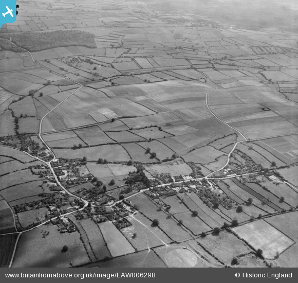
eaw006298 ENGLAND (1947). Mill Field, the village of Laxton and surrounding countryside, Laxton, from the north-east, 1947
© Copyright OpenStreetMap contributors and licensed by the OpenStreetMap Foundation. 2024. Cartography is licensed as CC BY-SA.
Details
| Title | [EAW006298] Mill Field, the village of Laxton and surrounding countryside, Laxton, from the north-east, 1947 |
| Reference | EAW006298 |
| Date | 27-May-1947 |
| Link | |
| Place name | LAXTON |
| Parish | LAXTON AND MOORHOUSE |
| District | |
| Country | ENGLAND |
| Easting / Northing | 472070, 366951 |
| Longitude / Latitude | -0.92112229059285, 53.194467311046 |
| National Grid Reference | SK721670 |
Pins
 totoro |
Tuesday 18th of February 2014 05:20:48 PM | |
 totoro |
Tuesday 18th of February 2014 05:20:03 PM | |
 totoro |
Tuesday 18th of February 2014 05:18:01 PM | |
 totoro |
Tuesday 18th of February 2014 05:09:19 PM | |
 totoro |
Tuesday 18th of February 2014 04:31:14 PM | |
 totoro |
Tuesday 18th of February 2014 04:30:41 PM | |
 totoro |
Tuesday 18th of February 2014 04:22:33 PM | |
 totoro |
Tuesday 18th of February 2014 04:22:15 PM | |
 totoro |
Tuesday 18th of February 2014 04:15:32 PM | |
 totoro |
Tuesday 18th of February 2014 04:12:49 PM | |
 totoro |
Tuesday 18th of February 2014 04:10:24 PM |


![[EAW006298] Mill Field, the village of Laxton and surrounding countryside, Laxton, from the north-east, 1947](http://britainfromabove.org.uk/sites/all/libraries/aerofilms-images/public/100x100/EAW/006/EAW006298.jpg)
![[EAW003518] The village and surrounding countryside in the snow, Laxton, 1947. This image has been produced from a print.](http://britainfromabove.org.uk/sites/all/libraries/aerofilms-images/public/100x100/EAW/003/EAW003518.jpg)