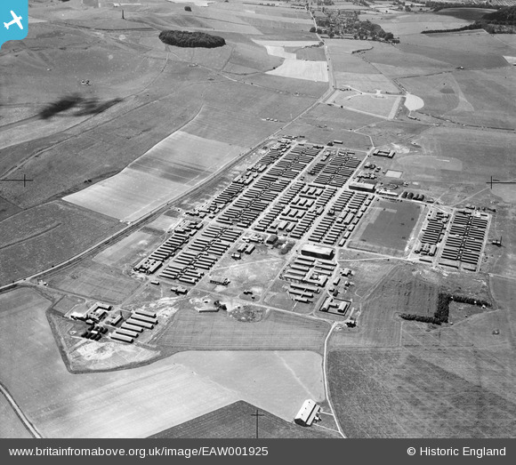
eaw001925 ENGLAND (1946). RAF Yatesbury, Yatesbury, from the north-east, 1946
© Copyright OpenStreetMap contributors and licensed by the OpenStreetMap Foundation. 2025. Cartography is licensed as CC BY-SA.
Details
| Title | [EAW001925] RAF Yatesbury, Yatesbury, from the north-east, 1946 |
| Reference | EAW001925 |
| Date | 12-July-1946 |
| Link | |
| Place name | YATESBURY |
| Parish | CHERHILL |
| District | |
| Country | ENGLAND |
| Easting / Northing | 407090, 170250 |
| Longitude / Latitude | -1.8980021284236, 51.430717297323 |
| National Grid Reference | SU071703 |
Pins
 dave |
Wednesday 1st of January 2020 07:55:08 PM | |
 Sparky |
Tuesday 19th of September 2017 01:51:58 PM | |
 Class31 |
Saturday 8th of February 2014 07:32:19 PM | |
 Class31 |
Saturday 8th of February 2014 07:30:00 PM | |
 Margaret |
Friday 23rd of August 2013 11:07:53 PM | |
 Margaret |
Friday 23rd of August 2013 11:07:17 PM | |
 Margaret |
Friday 23rd of August 2013 11:06:18 PM | |
 Margaret |
Friday 23rd of August 2013 11:02:45 PM | |
 Nick Pitt |
Friday 23rd of August 2013 04:05:45 PM | |
 bayleaf |
Friday 23rd of August 2013 03:46:40 PM | |
Yes, that's the Lansdowne monument on Cherhill Down and this is the camp at Yatesbury. Thanks! Katy |
Katy Whitaker |
Friday 23rd of August 2013 04:01:20 PM |
 bayleaf |
Friday 23rd of August 2013 03:45:48 PM | |
 bayleaf |
Friday 23rd of August 2013 03:44:46 PM | |
 bayleaf |
Friday 23rd of August 2013 03:43:56 PM | |
Seems to be a Halifax minus outer wings and engines |
 ken |
Tuesday 7th of November 2017 09:13:51 PM |
 bayleaf |
Friday 23rd of August 2013 03:42:56 PM |
User Comment Contributions
The view appears to show Yatesbury RAF camp situated to the west of Calne in Wiltshire. This section of the A4 crossing Cherhill Downs was widened to three lanes several years after this photo was taken. The view looks west. The Cherhill White Horse is hidden from view. It is just below the lip of the downs to the west of the plantation at the top of the image. Oldbury Camp Hillfort and the Lansdowne Monument are clearly seen to the left (south) of the Plantation. See image reference EAW002273 for an alternative close view of the Cherhill White Horse and Oldbury Camp seen from the north-west. |
 Margaret |
Sunday 11th of May 2014 05:46:13 AM |
Hi Margaret, We're really pleased to have a location for this group of images of Yatesbury Camp. The updated catalogue record will be posted here in due course. Yours, Katy Britain from Above Cataloguing Team Leader |
Katy Whitaker |
Tuesday 3rd of September 2013 12:22:30 PM |
On re-reading this entry, I see I wrongly stated that Yatesbury camp was west of Calne. It was located to the east of the town. |
 Margaret |
Sunday 11th of May 2014 05:46:13 AM |
This sequence goes on to eaw001931. |
 Chris Willis |
Friday 23rd of August 2013 11:21:45 PM |
Military camp. Many accommodation huts but no sign of any slit tranches or air raid shelters. |
 bayleaf |
Friday 23rd of August 2013 03:52:41 PM |

