
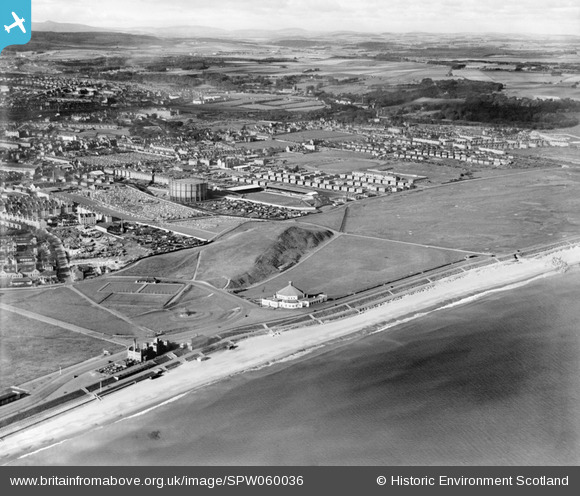
SPW060036 SCOTLAND (1938). Aberdeen, general view, showing Broad Hill and Esplanade. An oblique aerial photograph taken facing west.
© Copyright OpenStreetMap contributors and licensed by the OpenStreetMap Foundation. 2026. Cartography is licensed as CC BY-SA.
Details
| Title | [SPW060036] Aberdeen, general view, showing Broad Hill and Esplanade. An oblique aerial photograph taken facing west. |
| Reference | SPW060036 |
| Date | 1938 |
| Link | NRHE Collection item 1258274 |
| Place name | |
| Parish | ABERDEEN |
| District | CITY OF ABERDEEN |
| Country | SCOTLAND |
| Easting / Northing | 395020, 807440 |
| Longitude / Latitude | -2.0823353588962, 57.157984776523 |
| National Grid Reference | NJ950074 |
Pins

Celurca |
Tuesday 2nd of March 2021 01:08:48 PM | |
|
Celurca |
Tuesday 2nd of March 2021 01:04:43 PM | |
|
Dave |
Thursday 9th of May 2013 12:28:36 PM | |

Class31 |
Monday 12th of November 2012 12:11:48 PM | |
|
Class31 |
Monday 12th of November 2012 12:10:18 PM | |
|
Class31 |
Monday 12th of November 2012 12:09:40 PM | |
|
Class31 |
Monday 12th of November 2012 12:08:06 PM | |
|
Class31 |
Monday 12th of November 2012 12:07:12 PM | |
|
Class31 |
Monday 12th of November 2012 12:05:14 PM | |
|
Class31 |
Monday 12th of November 2012 12:04:28 PM | |
Unfortunately this is not Beach Boulevard, that is a modern road. This is an old extension of Constitution Road. |
DonsideGeek |
Thursday 5th of February 2015 08:11:03 PM |
|
Class31 |
Monday 12th of November 2012 12:04:10 PM | |
|
Class31 |
Monday 12th of November 2012 12:03:13 PM | |
|
Class31 |
Monday 12th of November 2012 12:02:30 PM |
User Comment Contributions
The beach area and facilities were not much changed twenty years later, but are altered by developments from the 1960s onwards, not invariably for the better. |
C R Munro |
Sunday 5th of August 2012 05:58:35 PM |