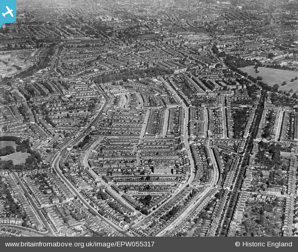
EPW055317 ENGLAND (1937). Residential streets around Lordship Lane and Landells Road, East Dulwich, 1937
© Copyright OpenStreetMap contributors and licensed by the OpenStreetMap Foundation. 2025. Cartography is licensed as CC BY-SA.
Details
| Title | [EPW055317] Residential streets around Lordship Lane and Landells Road, East Dulwich, 1937 |
| Reference | EPW055317 |
| Date | September-1937 |
| Link | |
| Place name | EAST DULWICH |
| Parish | |
| District | |
| Country | ENGLAND |
| Easting / Northing | 533965, 174832 |
| Longitude / Latitude | -0.071608314841425, 51.456106887039 |
| National Grid Reference | TQ340748 |
Pins
 Leslie B |
Tuesday 5th of July 2022 11:13:43 PM | |
 South Londoner |
Saturday 31st of December 2016 06:07:32 PM | |
 South Londoner |
Saturday 31st of December 2016 06:05:57 PM | |
 South Londoner |
Saturday 31st of December 2016 06:04:45 PM | |
 John Wass |
Sunday 24th of May 2015 04:13:24 PM | |
 brianbeckett |
Tuesday 30th of September 2014 12:27:42 PM | |
 Alan McFaden |
Tuesday 3rd of June 2014 10:36:44 PM | |
 Alan McFaden |
Tuesday 3rd of June 2014 10:36:13 PM | |
 Wordy |
Monday 5th of May 2014 06:45:48 PM | |
 Alan44 |
Tuesday 3rd of September 2013 04:57:58 PM | |
 Alan44 |
Tuesday 3rd of September 2013 04:50:07 PM | |
 Alan44 |
Tuesday 3rd of September 2013 04:44:45 PM | |
 Alan44 |
Tuesday 3rd of September 2013 04:42:35 PM | |
 Alan44 |
Tuesday 3rd of September 2013 04:26:22 PM | |
 Alan44 |
Sunday 1st of September 2013 04:53:27 PM |


