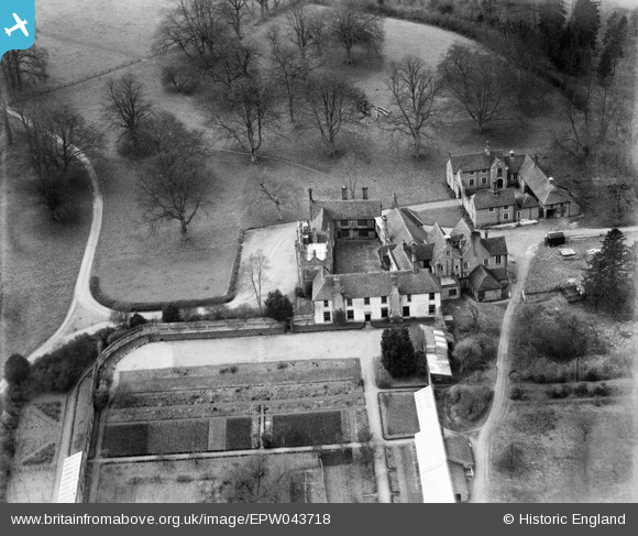
EPW043718 ENGLAND (1934). Gifford's Hall, Withermarsh Green, 1934
© Copyright OpenStreetMap contributors and licensed by the OpenStreetMap Foundation. 2025. Cartography is licensed as CC BY-SA.
Nearby Images (22)
Details
| Title | [EPW043718] Gifford's Hall, Withermarsh Green, 1934 |
| Reference | EPW043718 |
| Date | January-1934 |
| Link | |
| Place name | WITHERMARSH GREEN |
| Parish | STOKE-BY-NAYLAND |
| District | |
| Country | ENGLAND |
| Easting / Northing | 601799, 237411 |
| Longitude / Latitude | 0.93997239624681, 51.997985607405 |
| National Grid Reference | TM018374 |
Pins
 totoro |
Tuesday 3rd of December 2013 06:13:57 PM |


![[EPW043718] Gifford's Hall, Withermarsh Green, 1934](http://britainfromabove.org.uk/sites/all/libraries/aerofilms-images/public/100x100/EPW/043/EPW043718.jpg)
![[EAW036739] Gifford's Hall, Stoke-by-Nayland, 1951. This image has been produced from a print marked by Aerofilms Ltd for photo editing.](http://britainfromabove.org.uk/sites/all/libraries/aerofilms-images/public/100x100/EAW/036/EAW036739.jpg)
![[EPW043722] Gifford's Hall, Withermarsh Green, 1934](http://britainfromabove.org.uk/sites/all/libraries/aerofilms-images/public/100x100/EPW/043/EPW043722.jpg)
![[EPW043702] Gifford's Hall, Withermarsh Green, 1934](http://britainfromabove.org.uk/sites/all/libraries/aerofilms-images/public/100x100/EPW/043/EPW043702.jpg)
![[EPW043697] Gifford's Hall, Withermarsh Green, 1934. This image has been affected by flare.](http://britainfromabove.org.uk/sites/all/libraries/aerofilms-images/public/100x100/EPW/043/EPW043697.jpg)
![[EPW043724] Gifford's Hall, Withermarsh Green, 1934](http://britainfromabove.org.uk/sites/all/libraries/aerofilms-images/public/100x100/EPW/043/EPW043724.jpg)
![[EAW036742] Gifford's Hall, Stoke-by-Nayland, 1951. This image has been produced from a print marked by Aerofilms Ltd for photo editing.](http://britainfromabove.org.uk/sites/all/libraries/aerofilms-images/public/100x100/EAW/036/EAW036742.jpg)
![[EAW036744] Gifford's Hall and Gifford's Hall Park, Stoke-by-Nayland, 1951. This image has been produced from a print marked by Aerofilms Ltd for photo editing.](http://britainfromabove.org.uk/sites/all/libraries/aerofilms-images/public/100x100/EAW/036/EAW036744.jpg)
![[EPW043698] Gifford's Hall, Withermarsh Green, 1934](http://britainfromabove.org.uk/sites/all/libraries/aerofilms-images/public/100x100/EPW/043/EPW043698.jpg)
![[EPW043717] Gifford's Hall, Withermarsh Green, 1934](http://britainfromabove.org.uk/sites/all/libraries/aerofilms-images/public/100x100/EPW/043/EPW043717.jpg)
![[EPW043719] Gifford's Hall, Withermarsh Green, 1934](http://britainfromabove.org.uk/sites/all/libraries/aerofilms-images/public/100x100/EPW/043/EPW043719.jpg)
![[EPW043721] Gifford's Hall, Withermarsh Green, 1934](http://britainfromabove.org.uk/sites/all/libraries/aerofilms-images/public/100x100/EPW/043/EPW043721.jpg)
![[EAW036743] Gifford's Hall and walled garden, Stoke-by-Nayland, 1951. This image has been produced from a print.](http://britainfromabove.org.uk/sites/all/libraries/aerofilms-images/public/100x100/EAW/036/EAW036743.jpg)
![[EPW043720] Gifford's Hall, Withermarsh Green, 1934](http://britainfromabove.org.uk/sites/all/libraries/aerofilms-images/public/100x100/EPW/043/EPW043720.jpg)
![[EPW043703] Gifford's Hall, Withermarsh Green, 1934](http://britainfromabove.org.uk/sites/all/libraries/aerofilms-images/public/100x100/EPW/043/EPW043703.jpg)
![[EPW043723] Gifford's Hall, Withermarsh Green, 1934](http://britainfromabove.org.uk/sites/all/libraries/aerofilms-images/public/100x100/EPW/043/EPW043723.jpg)
![[EPW043701] Gifford's Hall, Withermarsh Green, 1934](http://britainfromabove.org.uk/sites/all/libraries/aerofilms-images/public/100x100/EPW/043/EPW043701.jpg)
![[EAW036741] Gifford's Hall and Gifford's Hall Park, Stoke-by-Nayland, 1951. This image has been produced from a print marked by Aerofilms Ltd for photo editing.](http://britainfromabove.org.uk/sites/all/libraries/aerofilms-images/public/100x100/EAW/036/EAW036741.jpg)
![[EAW036740] Gifford's Hall and Gifford's Hall Park, Stoke-by-Nayland, 1951. This image has been produced from a print marked by Aerofilms Ltd for photo editing.](http://britainfromabove.org.uk/sites/all/libraries/aerofilms-images/public/100x100/EAW/036/EAW036740.jpg)
![[EPW043700] Gifford's Hall, Withermarsh Green, 1934](http://britainfromabove.org.uk/sites/all/libraries/aerofilms-images/public/100x100/EPW/043/EPW043700.jpg)
![[EPW043699] Gifford's Hall, Withermarsh Green, 1934](http://britainfromabove.org.uk/sites/all/libraries/aerofilms-images/public/100x100/EPW/043/EPW043699.jpg)
![[EAW036745] Gifford's Hall and Gifford's Hall Park, Stoke-by-Nayland, from the south-west, 1951. This image has been produced from a print marked by Aerofilms Ltd for photo editing.](http://britainfromabove.org.uk/sites/all/libraries/aerofilms-images/public/100x100/EAW/036/EAW036745.jpg)