
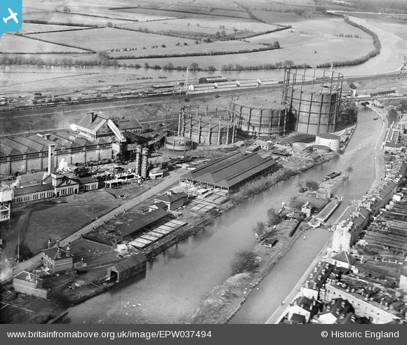
EPW037494 ENGLAND (1932). The Reading Gas Co Works alongside the River Kennet, Reading, 1932
© Copyright OpenStreetMap contributors and licensed by the OpenStreetMap Foundation. 2025. Cartography is licensed as CC BY-SA.
Nearby Images (6)
EPW037494

EPW000873

EPW037498

EPW037499

EPW037496

EPW037497

Details
| Title | [EPW037494] The Reading Gas Co Works alongside the River Kennet, Reading, 1932 |
| Reference | EPW037494 |
| Date | April-1932 |
| Link | |
| Place name | READING |
| Parish | |
| District | |
| Country | ENGLAND |
| Easting / Northing | 472730, 173634 |
| Longitude / Latitude | -0.95309198999112, 51.456518935464 |
| National Grid Reference | SU727736 |
Pins
 chainbull |
Tuesday 25th of November 2014 09:50:44 AM | |
 Class31 |
Wednesday 28th of May 2014 11:30:52 AM | |
Martin D |
Saturday 10th of May 2014 08:03:20 PM | |
MB |
Tuesday 1st of January 2013 06:29:02 PM | |
The line forks at Wokingham, as you say goes to Guildford & the other line goes to Waterloo. |
Martin D |
Saturday 10th of May 2014 07:58:14 PM |
MB |
Tuesday 1st of January 2013 06:28:22 PM | |
MB |
Tuesday 1st of January 2013 06:26:00 PM | |
MB |
Tuesday 1st of January 2013 06:25:39 PM | |
MB |
Tuesday 1st of January 2013 06:25:24 PM | |
MB |
Tuesday 1st of January 2013 06:23:41 PM | |
In fact this is the Sports Ground pavilion. The factory is to the left of this shot. |
Alf27 |
Sunday 2nd of February 2014 10:42:47 PM |

User Comment Contributions
 River Kennet & River Thames confluence, Reading 29/05/2009 |
Class31 |
Wednesday 28th of May 2014 11:47:36 AM |