
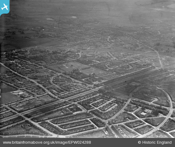
EPW024288 ENGLAND (1928). Housing surrounding Valence Avenue and Valence Park, Becontree, 1928
© Copyright OpenStreetMap contributors and licensed by the OpenStreetMap Foundation. 2025. Cartography is licensed as CC BY-SA.
Nearby Images (2)
EPW024288

EPW024292

Details
| Title | [EPW024288] Housing surrounding Valence Avenue and Valence Park, Becontree, 1928 |
| Reference | EPW024288 |
| Date | September-1928 |
| Link | |
| Place name | BECONTREE |
| Parish | |
| District | |
| Country | ENGLAND |
| Easting / Northing | 548136, 186352 |
| Longitude / Latitude | 0.13707416331178, 51.556097480447 |
| National Grid Reference | TQ481864 |
Pins

Dank |
Tuesday 16th of March 2021 05:32:02 PM | |
|
Dank |
Tuesday 16th of March 2021 05:31:05 PM | |
|
Dank |
Tuesday 16th of March 2021 05:29:49 PM | |
|
rac |
Wednesday 21st of October 2015 08:47:38 PM | |
|
GRP47 |
Saturday 28th of March 2015 03:08:01 PM | |
|
rac |
Wednesday 6th of August 2014 10:42:03 AM | |
|
rac |
Sunday 3rd of August 2014 07:38:34 PM | |
|
rac |
Sunday 3rd of August 2014 07:33:42 PM | |
|
rac |
Friday 1st of August 2014 09:58:48 AM | |
|
rac |
Wednesday 30th of July 2014 08:55:39 PM | |
|
GRP47 |
Thursday 19th of June 2014 02:20:10 PM | |
|
GRP47 |
Thursday 19th of June 2014 02:19:12 PM |
User Comment Contributions
Valance Avenue in its original format had a tramway running down the centre of the road where the grassed central reservation is now with Level Crossing gates at major cross points including Martins Corner |
WashRider |
Saturday 16th of January 2016 07:57:19 PM |