
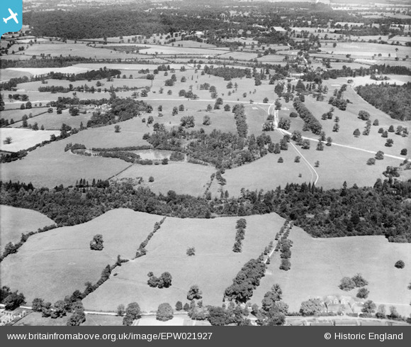
EPW021927 ENGLAND (1928). Gobions Garden and Gobions Wood, Brookmans Park, from the south-east, 1928
© Copyright OpenStreetMap contributors and licensed by the OpenStreetMap Foundation. 2025. Cartography is licensed as CC BY-SA.
Nearby Images (2)
EPW021927

EPW021928

Details
| Title | [EPW021927] Gobions Garden and Gobions Wood, Brookmans Park, from the south-east, 1928 |
| Reference | EPW021927 |
| Date | July-1928 |
| Link | |
| Place name | BROOKMANS PARK |
| Parish | NORTH MYMMS |
| District | |
| Country | ENGLAND |
| Easting / Northing | 525343, 203385 |
| Longitude / Latitude | -0.18545385658935, 51.714713039691 |
| National Grid Reference | TL253034 |
Pins

Ray Flack |
Friday 19th of September 2014 12:28:13 PM | |
|
Ray Flack |
Friday 19th of September 2014 12:27:15 PM | |
|
Ray Flack |
Friday 19th of September 2014 12:25:06 PM | |
|
Ray Flack |
Friday 19th of September 2014 12:24:03 PM | |
|
Ray Flack |
Friday 19th of September 2014 12:19:06 PM | |
|
Ray Flack |
Friday 19th of September 2014 12:13:43 PM | |
|
Ray Flack |
Friday 19th of September 2014 12:11:20 PM | |
|
Ray Flack |
Friday 19th of September 2014 12:03:51 PM | |
|
Ray Flack |
Friday 19th of September 2014 12:03:11 PM | |
|
Ray Flack |
Friday 19th of September 2014 12:02:14 PM | |
|
Ray Flack |
Friday 19th of September 2014 12:00:49 PM | |
|
Ray Flack |
Friday 19th of September 2014 11:59:58 AM | |
|
Ray Flack |
Friday 19th of September 2014 11:59:01 AM | |
|
Ray Flack |
Friday 19th of September 2014 11:58:18 AM | |
|
Ray Flack |
Friday 19th of September 2014 11:57:55 AM | |
|
Ray Flack |
Friday 19th of September 2014 11:57:22 AM | |
|
Ray Flack |
Friday 19th of September 2014 11:56:48 AM | |

Class31 |
Tuesday 12th of February 2013 04:58:10 PM | |
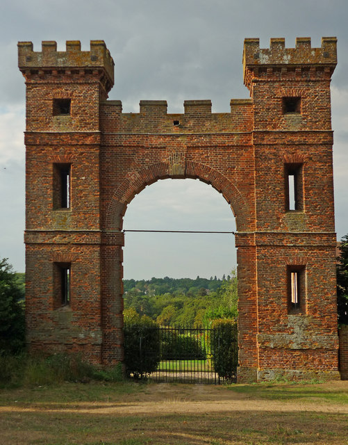
Now known as "The Folly" and stands between:- Swanley Bar Lane and Hawkshead Lane. From at least the 1390s (Victoria County History) the manor of More Hall was owned by the More family, who built Gobions House within the estate during the 16th century. Sir Thomas More, Henry VIII's Lord Chancellor, was executed in 1535, probably having written Utopia at More Hall. At this time the estate reverted to the Crown, being restored to the family in 1607. Basil More sold the estate in 1693, it being purchased in 1708 by Sir Jeremy Sambrooke (died 1754), who made major improvements to the property. In 1730 Charles Bridgeman, the Royal Gardener (died 1738), was employed to make a 'Pleasure Garden' in Great or Gobions Wood, detached from the house, this being shown on an estate map of around 1735 (Gloucestershire Record Office). The map shows the woodland containing various formal features, including a bowling green and canals linked by straight walks, enclosed by avenues crossing the adjacent fields and parkland. James Gibbs designed, around 1740, a temple facade to terminate the largest canal, together with the large Folly Arch, a three-storey gothick gateway, to terminate one of the main avenues at the southern boundary of the estate. |
Ray Flack |
Saturday 20th of September 2014 11:43:00 AM |
|
Class31 |
Tuesday 12th of February 2013 04:47:35 PM |
User Comment Contributions
The "Folly" Hawkshead Lane, and Swanley Lane. |
Ray Flack |
Saturday 20th of September 2014 11:45:28 AM |