
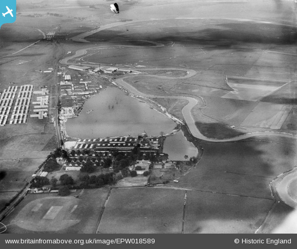
EPW018589 ENGLAND (1927). Stonar Camp and the North Lake, Sandwich, from the south, 1927
© Copyright OpenStreetMap contributors and licensed by the OpenStreetMap Foundation. 2024. Cartography is licensed as CC BY-SA.
Nearby Images (10)
EPW018589

EPW018582

EPW018583

EPW018585

EPW018590

EPW018587

EPW018581

EPW018586

EPW018584

EPW018588

Details
| Title | [EPW018589] Stonar Camp and the North Lake, Sandwich, from the south, 1927 |
| Reference | EPW018589 |
| Date | 22-June-1927 |
| Link | |
| Place name | SANDWICH |
| Parish | SANDWICH |
| District | |
| Country | ENGLAND |
| Easting / Northing | 633569, 158521 |
| Longitude / Latitude | 1.3493748197189, 51.277363801164 |
| National Grid Reference | TR336585 |
Pins
 Stubzi34 |
Wednesday 30th of March 2016 04:36:34 PM | |
The Laird |
Thursday 28th of August 2014 01:32:13 PM | |
The Laird |
Thursday 28th of August 2014 01:31:49 PM | |
The Laird |
Sunday 29th of June 2014 05:34:16 PM | |
The Laird |
Sunday 29th of June 2014 05:25:03 PM | |
The Laird |
Sunday 29th of June 2014 05:24:15 PM | |
The Laird |
Sunday 29th of June 2014 05:20:11 PM | |
MB |
Sunday 7th of October 2012 07:12:53 PM | |
MB |
Sunday 7th of October 2012 07:12:01 PM | |
MB |
Sunday 7th of October 2012 07:04:26 PM | |
MB |
Sunday 7th of October 2012 07:04:00 PM | |
MB |
Sunday 7th of October 2012 07:03:37 PM | |
A gravel pit in 1907 |
MB |
Sunday 7th of October 2012 07:06:25 PM |
User Comment Contributions
 The River Stour can be seen in this wide valley. It has taken a winding course, over a long period of time, forming great U shaped meanders (bends). Some of these meanders have then formed into oxbow lakes. The river has taken a new course across the neck of the 'U' and detached the meander from the river to become a lake. |
MM |
Friday 5th of April 2013 12:09:12 PM |
The River Stour provides two reasonable oxbow examples in this shot |
MB |
Sunday 7th of October 2012 07:18:27 PM |
Stonar Camp was a World War I army camp. The site is now largely lost under ballast works which have extended the North Lake. Before World War I Roman coins, swords and other remains had been found near Stonar House, also demolished following the development of the site |
MB |
Sunday 7th of October 2012 07:16:34 PM |


