
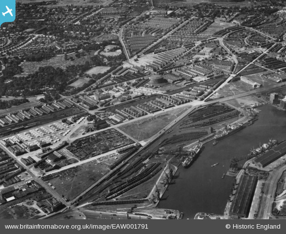
EAW001791 ENGLAND (1946). Price Street and environs, Birkenhead, 1946. This image has been produced from a print.
© Copyright OpenStreetMap contributors and licensed by the OpenStreetMap Foundation. 2025. Cartography is licensed as CC BY-SA.
Details
| Title | [EAW001791] Price Street and environs, Birkenhead, 1946. This image has been produced from a print. |
| Reference | EAW001791 |
| Date | 11-July-1946 |
| Link | |
| Place name | BIRKENHEAD |
| Parish | |
| District | |
| Country | ENGLAND |
| Easting / Northing | 330662, 389801 |
| Longitude / Latitude | -3.0429794731787, 53.400212847248 |
| National Grid Reference | SJ307898 |
Pins

XMAS DAY |
Saturday 23rd of September 2023 04:14:49 PM | |
|
XMAS DAY |
Saturday 23rd of September 2023 04:14:49 PM | |
|
XMAS DAY |
Saturday 23rd of September 2023 04:14:49 PM | |
|
XMAS DAY |
Thursday 15th of June 2023 07:25:12 AM | |
|
XMAS DAY |
Thursday 15th of June 2023 07:21:34 AM | |
|
XMAS DAY |
Thursday 15th of June 2023 07:20:06 AM | |
|
Kylix |
Friday 10th of December 2021 11:52:30 AM | |
|
kenc |
Sunday 19th of January 2020 06:07:14 PM | |
|
Robbied |
Sunday 27th of January 2019 09:56:16 PM | |
|
Robbied |
Sunday 27th of January 2019 09:54:15 PM | |

Sparky |
Wednesday 13th of September 2017 08:00:23 AM | |
|
Kylix |
Wednesday 9th of September 2015 02:55:53 PM | |
|
beast66606 |
Tuesday 9th of September 2014 09:41:56 AM |