
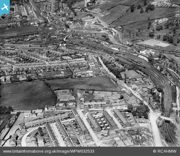
WPW032533 WALES (1930). General view of Pontnewynydd, oblique aerial view. 5"x4" black and white glass plate negative.
© Copyright OpenStreetMap contributors and licensed by the OpenStreetMap Foundation. 2025. Cartography is licensed as CC BY-SA.
Details
| Title | [WPW032533] General view of Pontnewynydd, oblique aerial view. 5"x4" black and white glass plate negative. |
| Reference | WPW032533 |
| Date | 1930 |
| Link | Coflein Archive Item 6370811 |
| Place name | |
| Parish | |
| District | |
| Country | WALES |
| Easting / Northing | 327420, 201750 |
| Longitude / Latitude | -3.0505630525387, 51.709325633297 |
| National Grid Reference | SO274018 |
Pins

monnow |
Thursday 1st of September 2022 09:25:20 AM | |
|
monnow |
Thursday 1st of September 2022 09:23:27 AM | |
|
Bren MacNeil |
Thursday 15th of December 2016 06:57:31 AM | |
|
johnarro |
Monday 3rd of August 2015 09:14:50 AM | |
|
RoyD |
Monday 13th of August 2012 08:20:15 PM | |
|
RoyD |
Monday 13th of August 2012 08:17:02 PM | |
This is not Branches Fork, which would be out of top left of the picture parallel with Hanbury Road. |
Kweffy |
Friday 23rd of November 2012 05:20:13 PM |
|
RoyD |
Monday 13th of August 2012 08:12:28 PM | |
|
RoyD |
Monday 13th of August 2012 08:12:04 PM | |
|
RoyD |
Monday 13th of August 2012 08:11:42 PM | |
|
RoyD |
Monday 13th of August 2012 08:11:07 PM | |
|
RoyD |
Monday 13th of August 2012 08:06:31 PM | |
|
Allan |
Monday 30th of July 2012 05:47:14 PM | |
|
Allan |
Monday 30th of July 2012 05:46:34 PM | |
|
Allan |
Monday 30th of July 2012 05:45:23 PM | |
|
Hivenhoe |
Tuesday 3rd of July 2012 08:43:52 AM | |
|
Hivenhoe |
Tuesday 3rd of July 2012 07:55:57 AM | |
|
dawlbach |
Wednesday 27th of June 2012 02:50:19 PM | |
The pin you marked St.Albans school is actually the Catholic church at the bottom of Conway Road.The school is in Pontypool Park which is not on this photo. |
Mark |
Wednesday 27th of June 2012 10:59:42 PM |
St.Albans School was towards the upper end of Conway R. It moved to the old Hanbury House at the park,later.I have tagged it,just to show where it is. |
RoyD |
Monday 13th of August 2012 08:10:24 PM |
|
dawlbach |
Wednesday 27th of June 2012 02:47:22 PM | |
I've looked at Google Earth and I think this is now part of a riverside walk. There is a football pitch above this point on the hill, but don't think this is it. |
Mark |
Wednesday 27th of June 2012 11:02:52 PM |
|
Mark |
Tuesday 26th of June 2012 11:10:47 PM | |
|
Mark |
Tuesday 26th of June 2012 11:10:05 PM |
User Comment Contributions
This photograph is of Pontnewynydd north of Pontypool. |
Arthur Llewellyn |
Wednesday 4th of July 2012 11:55:07 PM |
This is Wainfelin not Griffithstown |
Mark |
Wednesday 27th of June 2012 02:49:18 PM |
Hi Mark can you identify the PIN I've put on this photo?? and can you point out St Albans school?? thnx a lot |
dawlbach |
Wednesday 27th of June 2012 02:49:18 PM |