
WPW029840 WALES (1929). View of Penclawdd, oblique aerial view. 5"x4" black and white glass plate negative.

© Copyright OpenStreetMap contributors and licensed by the OpenStreetMap Foundation. 2026. Cartography is licensed as CC BY-SA.
Details
| Title | [WPW029840] View of Penclawdd, oblique aerial view. 5"x4" black and white glass plate negative. |
| Reference | WPW029840 |
| Date | September-1929 |
| Link | Coflein Archive Item 6370667 |
| Place name | |
| Parish | |
| District | |
| Country | WALES |
| Easting / Northing | 255200, 196000 |
| Longitude / Latitude | -4.0929659776701, 51.643664184433 |
| National Grid Reference | SS552960 |
Pins

Class31 |
Saturday 27th of July 2013 10:25:57 PM | |
|
Class31 |
Saturday 27th of July 2013 10:17:15 PM | |
|
Class31 |
Saturday 27th of July 2013 10:15:20 PM | |
|
Class31 |
Saturday 27th of July 2013 10:07:05 PM | |
|
Class31 |
Saturday 27th of July 2013 10:04:45 PM | |

Muc |
Sunday 30th of June 2013 09:28:14 PM | |
This has the name The Railway Inn on when viewed today 27th July 2013.See photograph. |
Class31 |
Saturday 27th of July 2013 10:10:03 PM |
|
Louis |
Saturday 19th of January 2013 04:16:20 PM | |
|
Fluclo |
Wednesday 26th of December 2012 11:38:05 AM | |
|
Class31 |
Saturday 4th of August 2012 09:25:57 PM | |
|
Class31 |
Saturday 4th of August 2012 09:21:58 PM | |
|
Class31 |
Saturday 4th of August 2012 09:20:28 PM | |
|
Class31 |
Saturday 4th of August 2012 09:17:45 PM | |
|
Class31 |
Saturday 4th of August 2012 09:15:35 PM | |
|
Class31 |
Saturday 4th of August 2012 09:13:59 PM | |
|
Tony Gos |
Sunday 8th of July 2012 09:00:09 AM | |
|
BigglesH |
Wednesday 27th of June 2012 03:22:16 PM | |
Tabernacle, Penclawdd |
Class31 |
Saturday 4th of August 2012 09:11:47 PM |
|
BigglesH |
Wednesday 27th of June 2012 03:20:32 PM |


User Comment Contributions
This is the North Gower village of Penclawdd |
Swansea Jack |
Sunday 20th of October 2013 02:56:05 PM |

Photograph of County Police Station. |
Class31 |
Saturday 27th of July 2013 10:13:39 PM |
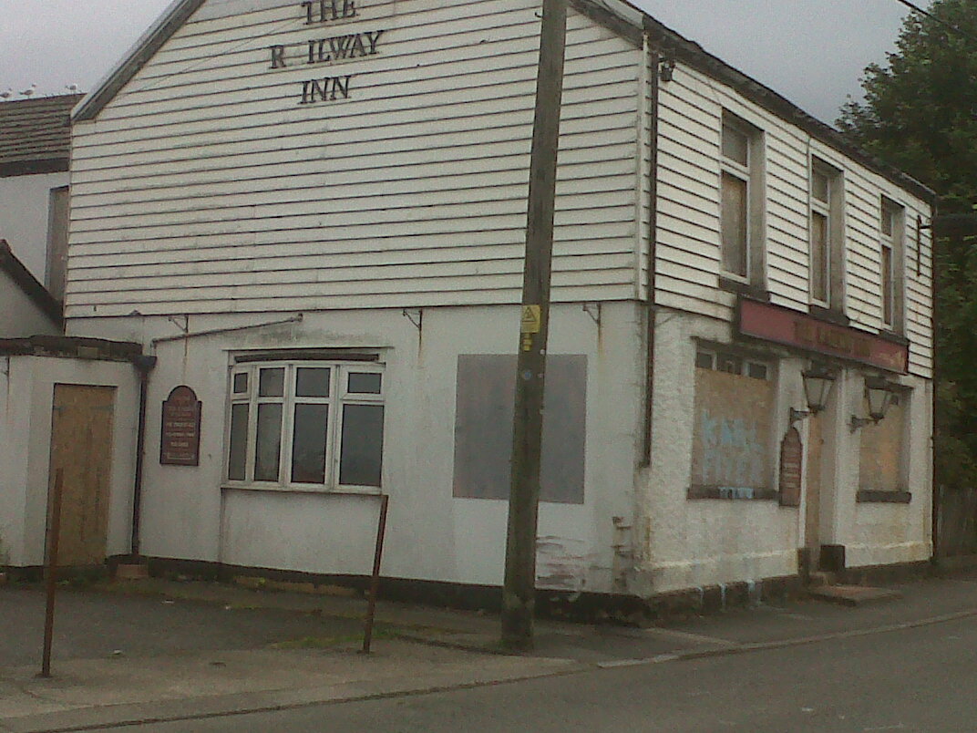
The Railway Inn PH viewed today 27th July 2013. |
Class31 |
Saturday 27th of July 2013 10:11:00 PM |
I have taken a tour around Penclawdd and I have identified some of the features shown in the photo. The photo is taken looking west. It is interesting that the Police Station was only built in 1926 and the building is still there. |
Class31 |
Saturday 4th of August 2012 09:32:22 PM |
Yes it's Pen-clawdd, looking down on the old site where the chimney is, of the now long gone Tin Plate Works & Lead & Silver Works. |
Tony Gos |
Saturday 7th of July 2012 08:54:10 PM |
Found it! It's Pen-clawdd, across the estuary from Llanelli. The railway is disused and mostly disappeared, the chimney gone and the estuary largely silted up, but it's definitely the same place. The steeple belongs to the Tabernacle church. |
Tony D |
Wednesday 4th of July 2012 12:58:15 PM |
I don't think it's Ferryside because the curvature of the railway doesn't appear to be right. Having said that I have tried and better tried but I can't get this one. |
Class31 |
Wednesday 27th of June 2012 07:53:19 PM |
I think it's Ferryside, photographed from North. |
BigglesH |
Wednesday 27th of June 2012 06:21:21 PM |
Estuary town. Shadows point right, so if morning, photo points southwest. Later in day? possibly west coast. Railway seems to reduce to single track under plane. |
BigglesH |
Wednesday 27th of June 2012 03:30:09 PM |