
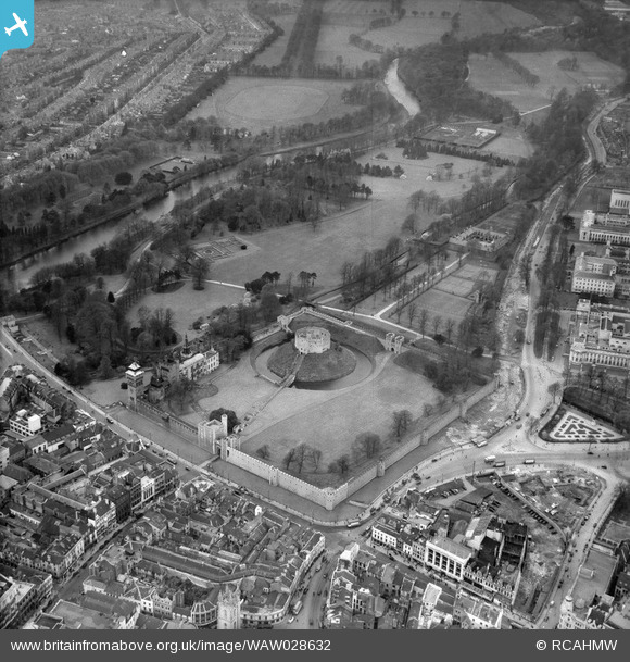
WAW028632 WALES (1950). View of Cardiff showing castle and Bute Park
© Copyright OpenStreetMap contributors and licensed by the OpenStreetMap Foundation. 2026. Cartography is licensed as CC BY-SA.
Nearby Images (48)
WPW001000

WPW001001

WPW001002

WPW001003

WPW001004

WPW001008

WPW001009

WPW001010

WPW001014

WPW001035

WPW016914

WPW016915

WPW016916

WPW016917

WPW016918

WPW016919

WPW016920

WPW029422

WPW029423

WPW029424

WPW029425

WPW029427

WPW029429

WPW041787

WPW041788

WPW041789

WPW041790

WPW041791

WPW041792

WPW041793

WPW041794

WPW041795

WPW052624

WPW052659

WPW052660

WPW052661

WPW052662

WPW052663

WPW052664

WPW054861

WPW054863

WPW054864

WPW054865

WPW055450

WPW055451

WPW055452

WPW055453

WPW055454

Details
| Title | [WAW028632] View of Cardiff showing castle and Bute Park |
| Reference | WAW028632 |
| Date | 6-April-1950 |
| Link | Coflein Archive Item 6414184 |
| Place name | |
| Parish | |
| District | |
| Country | WALES |
| Easting / Northing | 318170, 176360 |
| Longitude / Latitude | -3.1785006478589, 51.479784917149 |
| National Grid Reference | ST182764 |
Pins

Alan McFaden |
Saturday 9th of August 2014 09:48:15 AM | |
|
Alan McFaden |
Saturday 9th of August 2014 09:47:26 AM | |
|
Alan McFaden |
Saturday 9th of August 2014 09:46:54 AM | |
|
Alan McFaden |
Thursday 22nd of May 2014 09:31:46 AM | |

Class31 |
Thursday 15th of May 2014 11:26:11 PM | |
|
Class31 |
Thursday 15th of May 2014 11:25:57 PM | |
|
Class31 |
Thursday 15th of May 2014 11:25:27 PM | |
|
Class31 |
Thursday 15th of May 2014 11:25:06 PM | |
|
Class31 |
Thursday 15th of May 2014 11:24:29 PM | |
|
Class31 |
Thursday 15th of May 2014 11:24:10 PM | |
|
Class31 |
Thursday 15th of May 2014 11:23:53 PM |


