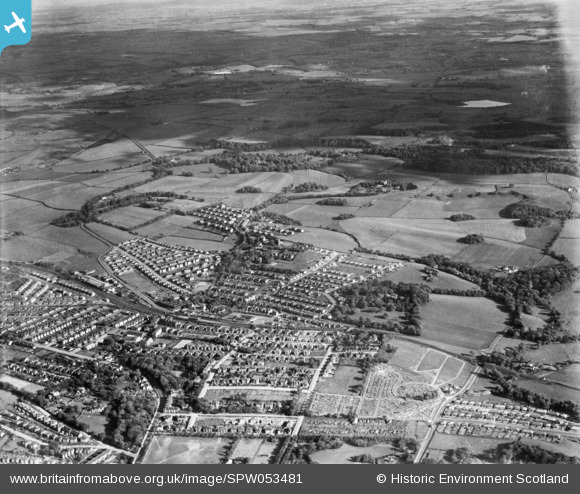
SPW053481 SCOTLAND (1937). General view, Burnside, Rutherglen, Lanarkshire, Scotland, 1937. An oblique aerial photograph, taken facing south.
© Copyright OpenStreetMap contributors and licensed by the OpenStreetMap Foundation. 2026. Cartography is licensed as CC BY-SA.
Details
| Title | [SPW053481] General view, Burnside, Rutherglen, Lanarkshire, Scotland, 1937. An oblique aerial photograph, taken facing south. |
| Reference | SPW053481 |
| Date | 1937 |
| Link | NRHE Collection item 1452115 |
| Place name | |
| Parish | RUTHERGLEN (SOUTH LANARKSHIRE) |
| District | CITY OF GLASGOW |
| Country | SCOTLAND |
| Easting / Northing | 261930, 659710 |
| Longitude / Latitude | -4.2034713782548, 55.8109150122 |
| National Grid Reference | NS619597 |
Pins

Jamie |
Wednesday 8th of October 2025 12:42:19 PM | |

Jamie |
Wednesday 8th of October 2025 12:41:11 PM | |

Holbay |
Monday 12th of April 2021 05:01:54 PM | |

Holbay |
Monday 12th of April 2021 04:57:14 PM | |

Graeme |
Saturday 1st of February 2020 10:50:59 AM | |

David Meikle |
Friday 13th of September 2019 06:25:53 PM | |

David Meikle |
Friday 13th of September 2019 06:22:20 PM | |

David Meikle |
Friday 13th of September 2019 06:20:20 PM | |

David Meikle |
Friday 13th of September 2019 06:19:07 PM | |

BobbyS |
Sunday 23rd of November 2014 08:42:12 PM | |

BobbyS |
Sunday 23rd of November 2014 08:39:18 PM | |

BobbyS |
Sunday 23rd of November 2014 08:37:39 PM | |

BobbyS |
Sunday 23rd of November 2014 08:25:23 PM | |

BobbyS |
Sunday 23rd of November 2014 08:23:30 PM | |

BobbyS |
Sunday 23rd of November 2014 08:22:13 PM | |

BobbyS |
Sunday 23rd of November 2014 08:20:33 PM | |

BobbyS |
Sunday 23rd of November 2014 08:19:20 PM |

