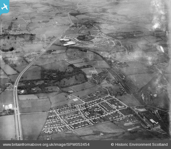
SPW053454 SCOTLAND (1937). General view, Springboig, Glasgow, Lanarkshire, Scotland, 1937. An oblique aerial photograph, taken facing east.
© Copyright OpenStreetMap contributors and licensed by the OpenStreetMap Foundation. 2026. Cartography is licensed as CC BY-SA.
Details
| Title | [SPW053454] General view, Springboig, Glasgow, Lanarkshire, Scotland, 1937. An oblique aerial photograph, taken facing east. |
| Reference | SPW053454 |
| Date | 1937 |
| Link | NRHE Collection item 1452098 |
| Place name | |
| Parish | GLASGOW (CITY OF GLASGOW) |
| District | CITY OF GLASGOW |
| Country | SCOTLAND |
| Easting / Northing | 265700, 664620 |
| Longitude / Latitude | -4.1457809872352, 55.856068051742 |
| National Grid Reference | NS657646 |
Pins

Dave |
Friday 19th of December 2025 06:40:00 PM | |

John Cole |
Wednesday 7th of August 2024 12:51:32 PM | |

John Cole |
Wednesday 7th of August 2024 12:50:47 PM | |

Graham mck |
Wednesday 13th of December 2023 09:52:37 PM | |

navaho56 |
Monday 4th of March 2019 11:27:30 AM | |

navaho56 |
Monday 4th of March 2019 11:20:49 AM | |

navaho56 |
Monday 4th of March 2019 11:16:45 AM | |

navaho56 |
Monday 4th of March 2019 11:14:56 AM | |

navaho56 |
Monday 4th of March 2019 09:18:54 AM | |

navaho56 |
Monday 4th of March 2019 09:15:52 AM | |

navaho56 |
Monday 4th of March 2019 09:12:07 AM | |

navaho56 |
Monday 4th of March 2019 09:10:10 AM | |

navaho56 |
Monday 4th of March 2019 08:49:46 AM | |

navaho56 |
Sunday 17th of February 2019 10:10:12 AM | |

navaho56 |
Sunday 17th of February 2019 10:07:58 AM | |

navaho56 |
Thursday 18th of January 2018 04:05:05 PM | |

navaho56 |
Friday 24th of February 2017 08:11:01 PM | |

navaho56 |
Friday 24th of February 2017 08:07:48 PM | |

navaho56 |
Friday 24th of February 2017 08:04:51 PM | |

navaho56 |
Friday 24th of February 2017 07:09:19 PM | |

Class31 |
Tuesday 30th of June 2015 04:26:22 PM | |
Thank you.. |

weesue |
Tuesday 30th of June 2015 04:27:18 PM |

Class31 |
Tuesday 30th of June 2015 04:23:02 PM | |

Class31 |
Tuesday 30th of June 2015 04:21:31 PM | |

Class31 |
Tuesday 30th of June 2015 04:20:22 PM | |

Class31 |
Tuesday 30th of June 2015 04:09:26 PM | |

Class31 |
Tuesday 30th of June 2015 04:08:14 PM | |

Billy Turner |
Friday 31st of October 2014 10:26:51 PM | |

Billy Turner |
Friday 31st of October 2014 10:24:47 PM | |

Billy Turner |
Friday 31st of October 2014 10:20:24 PM | |

Billy Turner |
Friday 31st of October 2014 10:05:20 PM | |

Billy Turner |
Friday 31st of October 2014 07:33:53 PM | |

Billy Turner |
Friday 31st of October 2014 07:09:40 PM | |

Billy Turner |
Thursday 30th of October 2014 08:39:18 PM | |

Billy Turner |
Thursday 30th of October 2014 08:22:37 PM | |

Billy Turner |
Thursday 30th of October 2014 08:19:09 PM | |

Billy Turner |
Thursday 30th of October 2014 08:09:23 PM | |

Billy Turner |
Thursday 30th of October 2014 08:07:57 PM |
User Comment Contributions

Can anyone tell me of "Hollowglen Farm" is on this image... I only have one picture of the Farm, where my mum was born... Thank you.. |

weesue |
Tuesday 30th of June 2015 04:27:15 PM |
I have found this caption for your photograph. "Hollowglen Farm about 1900, with on the left the lane leading northwards to Lightburn Hospital, now Hollowglen Road." This is on http://www.glasgowhistory.co.uk/Books/Shettleston%202/Section%20II.htm |

Class31 |
Tuesday 30th of June 2015 04:14:32 PM |
I have flagged the location as requested. |

Class31 |
Tuesday 30th of June 2015 04:27:15 PM |


