
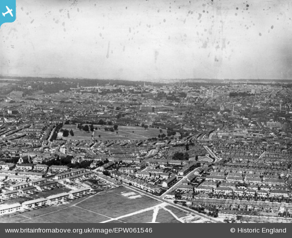
EPW061546 ENGLAND (1939). A cityscape from Upper Knowle towards the city centre, Bristol, from the south-east, 1939. This image has been produced from a damaged print.
© Copyright OpenStreetMap contributors and licensed by the OpenStreetMap Foundation. 2026. Cartography is licensed as CC BY-SA.
Details
| Title | [EPW061546] A cityscape from Upper Knowle towards the city centre, Bristol, from the south-east, 1939. This image has been produced from a damaged print. |
| Reference | EPW061546 |
| Date | 5-June-1939 |
| Link | |
| Place name | BRISTOL |
| Parish | |
| District | |
| Country | ENGLAND |
| Easting / Northing | 360260, 170867 |
| Longitude / Latitude | -2.5717604270378, 51.434915883103 |
| National Grid Reference | ST603709 |
Pins

James Blake |
Sunday 20th of October 2024 02:54:06 PM | |

John Swain |
Thursday 18th of May 2017 08:48:40 AM | |
|
John Swain |
Thursday 18th of May 2017 08:24:27 AM | |
|
John Swain |
Wednesday 17th of May 2017 11:17:44 AM | |
|
John Swain |
Tuesday 16th of May 2017 04:07:50 PM | |
|
John Swain |
Tuesday 16th of May 2017 04:01:13 PM | |
|
John Swain |
Tuesday 16th of May 2017 03:48:41 PM | |
These were bombed in WW2. Are you thinking of Cumberland Basin? |
J |
Tuesday 31st of January 2023 01:14:10 PM |
|
John Swain |
Tuesday 16th of May 2017 03:42:39 PM | |
|
John Swain |
Tuesday 16th of May 2017 03:29:45 PM | |
|
John Swain |
Tuesday 16th of May 2017 03:19:31 PM | |
|
John Swain |
Tuesday 16th of May 2017 03:17:28 PM | |
|
John Swain |
Tuesday 16th of May 2017 03:16:44 PM | |
|
John Swain |
Tuesday 16th of May 2017 03:15:38 PM | |
|
John Swain |
Tuesday 16th of May 2017 03:14:14 PM | |
|
John Swain |
Tuesday 16th of May 2017 03:13:04 PM | |
|
John Swain |
Tuesday 16th of May 2017 03:11:15 PM | |
|
John Swain |
Tuesday 16th of May 2017 03:10:07 PM | |
|
John Swain |
Tuesday 16th of May 2017 03:09:04 PM | |
|
John Swain |
Tuesday 16th of May 2017 03:07:24 PM | |
|
John Swain |
Tuesday 16th of May 2017 03:03:53 PM | |
|
John Swain |
Tuesday 16th of May 2017 03:01:08 PM | |
|
John Swain |
Tuesday 16th of May 2017 03:00:01 PM | |
|
John Swain |
Tuesday 16th of May 2017 02:59:26 PM | |
|
John Swain |
Tuesday 16th of May 2017 02:58:30 PM | |
|
John Swain |
Tuesday 16th of May 2017 02:56:05 PM | |
|
John Swain |
Tuesday 16th of May 2017 02:54:02 PM | |
|
kent2 |
Wednesday 28th of January 2015 12:56:17 PM | |
|
tapanddie |
Saturday 3rd of January 2015 05:29:11 PM | |
This contributor first visited Redcatch Park in October 1962, when staying in lodgings in Woodbridge Road. The park had been allotments throughout most of the 1930s, but was opened as a valued green space in Knowle just prior to the outbreak of World War II in September 1939, when the neighbouring interwar council estate at Knowle Park had been completed. |
John Swain |
Tuesday 16th of May 2017 02:51:24 PM |