
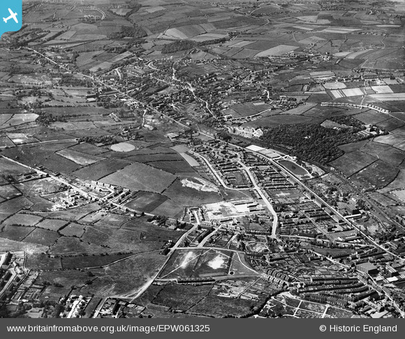
EPW061325 ENGLAND (1939). Carlinghow, Wilton Park and Brown Hill, Batley, from the south-east, 1939
© Copyright OpenStreetMap contributors and licensed by the OpenStreetMap Foundation. 2026. Cartography is licensed as CC BY-SA.
Details
| Title | [EPW061325] Carlinghow, Wilton Park and Brown Hill, Batley, from the south-east, 1939 |
| Reference | EPW061325 |
| Date | 2-June-1939 |
| Link | |
| Place name | BATLEY |
| Parish | |
| District | |
| Country | ENGLAND |
| Easting / Northing | 423167, 424847 |
| Longitude / Latitude | -1.6488957254217, 53.719294707175 |
| National Grid Reference | SE232248 |
Pins

BatleySL |
Thursday 3rd of August 2023 07:34:10 PM | |
|
trevpau |
Friday 6th of January 2023 10:25:25 PM | |
|
trevpau |
Friday 6th of January 2023 10:14:50 PM | |
|
trevpau |
Friday 6th of January 2023 10:06:56 PM | |
|
trevpau |
Friday 6th of January 2023 10:04:29 PM | |
|
trevpau |
Friday 6th of January 2023 10:01:34 PM | |
|
trevpau |
Friday 6th of January 2023 09:59:12 PM | |
|
trevpau |
Friday 6th of January 2023 09:57:07 PM | |
|
Surjeet Singh Notay |
Sunday 23rd of January 2022 03:38:30 PM | |
|
Graham Cass |
Monday 17th of January 2022 02:50:36 PM | |
|
Graham Cass |
Monday 17th of January 2022 02:42:39 PM | |
|
Graham Cass |
Monday 17th of January 2022 02:40:26 PM | |
|
Andrew Kenny |
Thursday 4th of February 2021 09:02:39 PM | |
|
HOLMES |
Wednesday 3rd of June 2020 06:07:56 PM | |
|
HOLMES |
Wednesday 3rd of June 2020 06:01:43 PM | |
|
Bev |
Thursday 23rd of January 2020 09:45:08 PM | |
|
Graham Cass |
Monday 15th of January 2018 04:16:01 PM | |
|
HOLMES |
Thursday 16th of March 2017 07:48:58 PM | |
Birstall Lower closed to passengers on 31st December 1916. |
Phill T |
Sunday 14th of June 2020 10:22:45 AM |
|
HOLMES |
Thursday 16th of March 2017 07:41:32 PM | |

Cabby |
Thursday 17th of November 2016 06:13:58 AM | |
|
Martin |
Tuesday 27th of September 2016 12:58:20 PM | |
|
kieron hill |
Sunday 10th of July 2016 06:33:19 PM | |
|
kieron hill |
Thursday 30th of June 2016 08:15:45 PM | |
|
franco21 |
Tuesday 8th of March 2016 02:38:37 PM | |
|
Cabby |
Wednesday 20th of May 2015 08:33:56 PM | |
|
Drigdog |
Friday 17th of April 2015 04:14:50 PM | |
|
KITKATBERTIE |
Tuesday 15th of July 2014 09:15:53 AM | |
|
KITKATBERTIE |
Friday 4th of July 2014 05:11:37 PM | |
|
KITKATBERTIE |
Friday 4th of July 2014 05:08:50 PM | |
|
KITKATBERTIE |
Friday 4th of July 2014 05:00:33 PM | |
 |
Cabby |
Friday 7th of March 2014 10:04:25 AM |
|
Cabby |
Tuesday 25th of February 2014 10:48:12 PM | |
|
Cabby |
Tuesday 25th of February 2014 10:45:14 PM | |
|
Cabby |
Sunday 23rd of February 2014 03:41:30 PM | |
|
Cabby |
Sunday 23rd of February 2014 03:39:01 PM | |
|
Cabby |
Sunday 23rd of February 2014 03:37:40 PM | |
|
Cabby |
Sunday 23rd of February 2014 03:36:13 PM | |
|
Cabby |
Sunday 23rd of February 2014 03:29:38 PM | |
|
Cabby |
Wednesday 19th of February 2014 09:35:12 PM | |
|
Cabby |
Wednesday 19th of February 2014 09:33:32 PM | |
|
Gerddi |
Tuesday 11th of February 2014 08:10:21 PM | |
|
Gerddi |
Tuesday 11th of February 2014 08:09:11 PM | |
|
Gerddi |
Tuesday 11th of February 2014 08:07:58 PM | |
|
Gerddi |
Tuesday 11th of February 2014 08:07:13 PM | |
|
Gerddi |
Tuesday 11th of February 2014 08:06:37 PM | |

Class31 |
Thursday 31st of October 2013 10:37:41 PM | |
|
Class31 |
Thursday 31st of October 2013 10:34:48 PM | |
|
Class31 |
Thursday 31st of October 2013 10:31:56 PM | |
|
Class31 |
Thursday 31st of October 2013 10:30:13 PM | |
|
Class31 |
Thursday 31st of October 2013 10:29:02 PM | |
|
Class31 |
Thursday 31st of October 2013 10:27:41 PM | |
|
Class31 |
Thursday 31st of October 2013 10:26:57 PM | |
|
Class31 |
Thursday 31st of October 2013 10:26:06 PM |


