
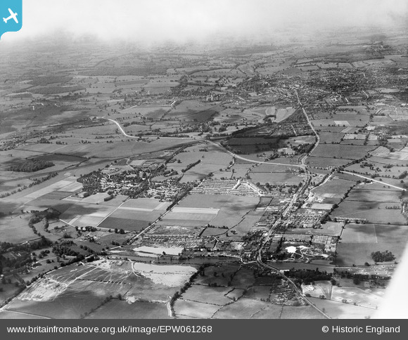
EPW061268 ENGLAND (1939). St Albans in the distance, Napsbury Hospital and the village, London Colney, from the south-east, 1939
© Copyright OpenStreetMap contributors and licensed by the OpenStreetMap Foundation. 2026. Cartography is licensed as CC BY-SA.
Details
| Title | [EPW061268] St Albans in the distance, Napsbury Hospital and the village, London Colney, from the south-east, 1939 |
| Reference | EPW061268 |
| Date | 31-May-1939 |
| Link | |
| Place name | LONDON COLNEY |
| Parish | LONDON COLNEY |
| District | |
| Country | ENGLAND |
| Easting / Northing | 517753, 203680 |
| Longitude / Latitude | -0.29517774473936, 51.71900959878 |
| National Grid Reference | TL178037 |
Pins

John W |
Thursday 30th of April 2026 09:30:38 PM | |
|
John W |
Thursday 30th of April 2026 09:20:39 PM | |
|
John W |
Sunday 4th of June 2023 12:33:18 PM | |
|
John W |
Sunday 4th of June 2023 12:30:40 PM | |
|
John W |
Saturday 11th of July 2020 06:34:48 PM | |
|
John W |
Saturday 11th of July 2020 06:31:06 PM | |
|
John W |
Saturday 11th of July 2020 06:30:33 PM | |
|
John W |
Thursday 1st of June 2017 05:17:58 PM | |
|
John W |
Monday 13th of June 2016 05:31:39 PM | |
|
John W |
Monday 13th of June 2016 05:29:26 PM | |
|
John W |
Sunday 1st of May 2016 10:57:12 AM | |
|
John W |
Sunday 1st of May 2016 10:55:49 AM | |
|
John W |
Sunday 1st of May 2016 10:51:10 AM | |
|
John W |
Sunday 1st of May 2016 10:39:02 AM | |
|
John W |
Friday 29th of April 2016 09:14:53 PM | |
|
John W |
Friday 29th of April 2016 09:13:22 PM | |
|
John W |
Friday 29th of April 2016 09:12:22 PM | |
|
John W |
Friday 29th of April 2016 09:11:06 PM | |
|
John W |
Friday 29th of April 2016 09:09:57 PM | |
|
John W |
Friday 29th of April 2016 09:07:48 PM | |
|
Chriss |
Sunday 3rd of January 2016 02:08:11 PM | |
|
Chriss |
Sunday 3rd of January 2016 02:05:46 PM | |
It opened in 1905, and was only served by the Slow lines. The 1959 closure came about when the diesel multiple units took over local services. |
John W |
Monday 13th of June 2016 05:28:09 PM |

Class31 |
Tuesday 18th of November 2014 03:40:15 PM |
