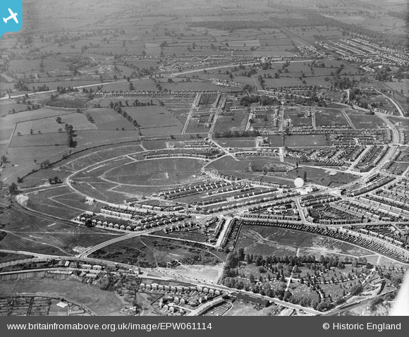
EPW061114 ENGLAND (1939). New housing estate under construction, Cheylesmore, 1939
© Copyright OpenStreetMap contributors and licensed by the OpenStreetMap Foundation. 2026. Cartography is licensed as CC BY-SA.
Details
| Title | [EPW061114] New housing estate under construction, Cheylesmore, 1939 |
| Reference | EPW061114 |
| Date | 30-May-1939 |
| Link | |
| Place name | CHEYLESMORE |
| Parish | |
| District | |
| Country | ENGLAND |
| Easting / Northing | 433828, 276985 |
| Longitude / Latitude | -1.5028688196291, 52.389464445371 |
| National Grid Reference | SP338770 |
Pins

Garland's Joke Shop |
Wednesday 13th of August 2025 04:32:19 PM | |

Garland's Joke Shop |
Wednesday 13th of August 2025 04:25:53 PM | |

Garland's Joke Shop |
Wednesday 13th of August 2025 04:24:44 PM | |

Garland's Joke Shop |
Wednesday 13th of August 2025 04:24:25 PM | |

Garland's Joke Shop |
Wednesday 13th of August 2025 04:23:47 PM | |

Garland's Joke Shop |
Wednesday 13th of August 2025 04:23:08 PM | |

Garland's Joke Shop |
Wednesday 13th of August 2025 04:22:39 PM | |

Garland's Joke Shop |
Wednesday 13th of August 2025 04:22:16 PM | |

Garland's Joke Shop |
Wednesday 13th of August 2025 04:21:04 PM | |

Garland's Joke Shop |
Wednesday 13th of August 2025 04:19:20 PM | |

Garland's Joke Shop |
Wednesday 13th of August 2025 04:18:55 PM | |

Garland's Joke Shop |
Wednesday 13th of August 2025 04:17:56 PM | |

Garland's Joke Shop |
Wednesday 13th of August 2025 04:16:51 PM | |

Garland's Joke Shop |
Wednesday 13th of August 2025 04:15:38 PM | |

Garland's Joke Shop |
Wednesday 13th of August 2025 04:12:11 PM | |

Garland's Joke Shop |
Wednesday 13th of August 2025 04:10:50 PM | |

Garland's Joke Shop |
Wednesday 13th of August 2025 04:09:37 PM | |

Garland's Joke Shop |
Wednesday 13th of August 2025 04:08:32 PM | |

Garland's Joke Shop |
Wednesday 13th of August 2025 04:08:00 PM | |

Steerpike |
Wednesday 24th of January 2024 12:47:49 PM | |

Peter Aslan |
Friday 30th of April 2021 06:20:19 PM | |

Peter Aslan |
Friday 17th of July 2015 08:58:02 AM | |

Alex |
Wednesday 6th of May 2015 02:33:39 PM | |

CovRes |
Tuesday 5th of May 2015 12:23:07 AM | |

CovRes |
Tuesday 5th of May 2015 12:21:55 AM | |

CovRes |
Tuesday 5th of May 2015 12:21:04 AM | |

tim |
Friday 25th of July 2014 06:22:57 PM | |

tim |
Friday 25th of July 2014 06:21:37 PM | |

tim |
Friday 25th of July 2014 06:19:43 PM | |

tim |
Friday 25th of July 2014 06:17:34 PM | |

Midland Red |
Wednesday 28th of August 2013 10:57:07 AM | |

Midland Red |
Wednesday 28th of August 2013 10:56:13 AM | |

Midland Red |
Wednesday 28th of August 2013 10:55:31 AM |

