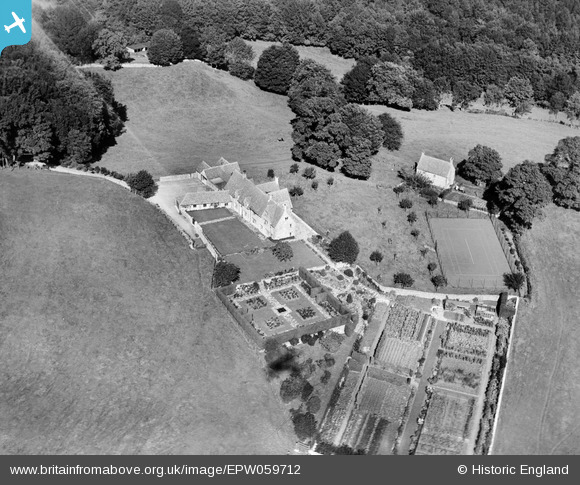
EPW059712 ENGLAND (1938). Steepways, Brimscombe, 1938
© Copyright OpenStreetMap contributors and licensed by the OpenStreetMap Foundation. 2024. Cartography is licensed as CC BY-SA.
Nearby Images (10)
Details
| Title | [EPW059712] Steepways, Brimscombe, 1938 |
| Reference | EPW059712 |
| Date | 29-September-1938 |
| Link | |
| Place name | BRIMSCOMBE |
| Parish | BRIMSCOMBE AND THRUPP |
| District | |
| Country | ENGLAND |
| Easting / Northing | 387671, 203376 |
| Longitude / Latitude | -2.1785300421773, 51.72850780093 |
| National Grid Reference | SO877034 |
Pins
Be the first to add a comment to this image!


![[EPW059712] Steepways, Brimscombe, 1938](http://britainfromabove.org.uk/sites/all/libraries/aerofilms-images/public/100x100/EPW/059/EPW059712.jpg)
![[EPW058876] Steepways, Quarhouse, 1938](http://britainfromabove.org.uk/sites/all/libraries/aerofilms-images/public/100x100/EPW/058/EPW058876.jpg)
![[EPW059714] Steepways and surrounding countryside, Brimscombe, 1938](http://britainfromabove.org.uk/sites/all/libraries/aerofilms-images/public/100x100/EPW/059/EPW059714.jpg)
![[EPW058875] Steepways, Quarhouse, 1938](http://britainfromabove.org.uk/sites/all/libraries/aerofilms-images/public/100x100/EPW/058/EPW058875.jpg)
![[EPW058872] Steepways, Quarhouse, 1938](http://britainfromabove.org.uk/sites/all/libraries/aerofilms-images/public/100x100/EPW/058/EPW058872.jpg)
![[EPW058873] Steepways, Quarhouse, 1938](http://britainfromabove.org.uk/sites/all/libraries/aerofilms-images/public/100x100/EPW/058/EPW058873.jpg)
![[EPW058874] Steepways, Quarhouse, 1938](http://britainfromabove.org.uk/sites/all/libraries/aerofilms-images/public/100x100/EPW/058/EPW058874.jpg)
![[EPW059711] Steepways, Brimscombe, 1938](http://britainfromabove.org.uk/sites/all/libraries/aerofilms-images/public/100x100/EPW/059/EPW059711.jpg)
![[EPW059713] Steepways, Brimscombe, 1938](http://britainfromabove.org.uk/sites/all/libraries/aerofilms-images/public/100x100/EPW/059/EPW059713.jpg)
![[EAW015795] Steepways Farm, Steepways and the surrounding countryside, Quarhouse, 1948. This image has been produced from a print.](http://britainfromabove.org.uk/sites/all/libraries/aerofilms-images/public/100x100/EAW/015/EAW015795.jpg)