
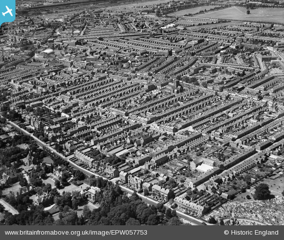
EPW057753 ENGLAND (1938). The residential area off Billing Road, St Edmund's Church and the town centre, Northampton, 1938
© Copyright OpenStreetMap contributors and licensed by the OpenStreetMap Foundation. 2025. Cartography is licensed as CC BY-SA.
Details
| Title | [EPW057753] The residential area off Billing Road, St Edmund's Church and the town centre, Northampton, 1938 |
| Reference | EPW057753 |
| Date | 21-June-1938 |
| Link | |
| Place name | NORTHAMPTON |
| Parish | |
| District | |
| Country | ENGLAND |
| Easting / Northing | 476529, 260771 |
| Longitude / Latitude | -0.87912422892165, 52.239404135798 |
| National Grid Reference | SP765608 |
Pins
 |
 Jay C |
Sunday 22nd of March 2020 09:07:55 AM |
Ritchiet |
Wednesday 3rd of February 2016 10:04:49 PM | |
geoff_1 |
Saturday 31st of August 2013 07:46:59 AM | |
geoff_1 |
Saturday 31st of August 2013 07:44:49 AM | |
geoff_1 |
Saturday 31st of August 2013 07:41:03 AM | |
geoff_1 |
Saturday 31st of August 2013 07:39:08 AM |