
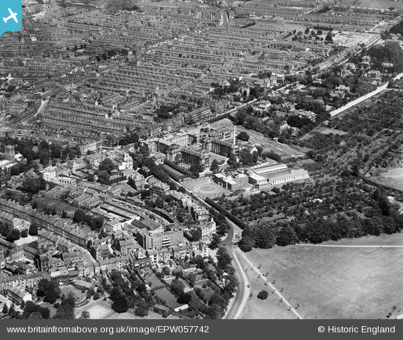
EPW057742 ENGLAND (1938). The General Hospital and the residential area alongside Billing Road, Northampton, 1938. This image has been produced from a damaged negative.
© Copyright OpenStreetMap contributors and licensed by the OpenStreetMap Foundation. 2026. Cartography is licensed as CC BY-SA.
Details
| Title | [EPW057742] The General Hospital and the residential area alongside Billing Road, Northampton, 1938. This image has been produced from a damaged negative. |
| Reference | EPW057742 |
| Date | 21-June-1938 |
| Link | |
| Place name | NORTHAMPTON |
| Parish | |
| District | |
| Country | ENGLAND |
| Easting / Northing | 476071, 260408 |
| Longitude / Latitude | -0.88591263112963, 52.23620437891 |
| National Grid Reference | SP761604 |
Pins

78 Derngate |
Saturday 8th of March 2014 07:06:12 PM | |
|
78 Derngate |
Saturday 8th of March 2014 07:06:08 PM | |

S Hope |
Saturday 24th of August 2013 04:30:25 PM | |
|
S Hope |
Saturday 24th of August 2013 04:28:59 PM | |
|
S Hope |
Saturday 24th of August 2013 04:28:34 PM | |
|
S Hope |
Saturday 24th of August 2013 04:27:40 PM | |
|
S Hope |
Saturday 24th of August 2013 04:26:03 PM | |
|
S Hope |
Saturday 24th of August 2013 04:24:56 PM | |
|
S Hope |
Saturday 24th of August 2013 04:24:36 PM | |
I only went swimming at Midsummer Meadows once as a child, does anyone have any memories of the pools to share? |
Denise Horn Nenescape |
Thursday 1st of September 2016 02:59:33 PM |
|
S Hope |
Saturday 24th of August 2013 04:24:18 PM | |
|
S Hope |
Saturday 24th of August 2013 04:23:38 PM |