
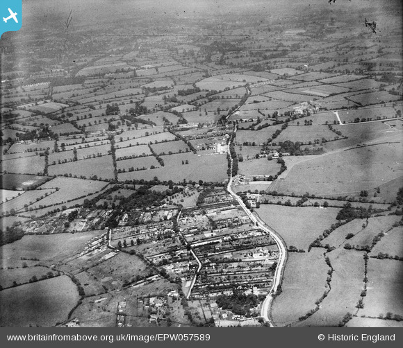
EPW057589 ENGLAND (1938). Cheswick Green and Solihull Race Course, Cheswick Green, 1938
© Copyright OpenStreetMap contributors and licensed by the OpenStreetMap Foundation. 2026. Cartography is licensed as CC BY-SA.
Details
| Title | [EPW057589] Cheswick Green and Solihull Race Course, Cheswick Green, 1938 |
| Reference | EPW057589 |
| Date | 14-June-1938 |
| Link | |
| Place name | CHESWICK GREEN |
| Parish | CHESWICK GREEN |
| District | |
| Country | ENGLAND |
| Easting / Northing | 413289, 276195 |
| Longitude / Latitude | -1.8047348305825, 52.383245452723 |
| National Grid Reference | SP133762 |
Pins

Nothing Better To Do |
Thursday 6th of April 2023 01:23:44 PM | |
|
Nothing Better To Do |
Thursday 6th of April 2023 01:19:54 PM | |
|
HeatherB61 |
Tuesday 12th of May 2020 08:46:21 PM | |
|
disco |
Wednesday 25th of September 2013 01:43:40 PM | |
|
disco |
Wednesday 25th of September 2013 01:39:03 PM | |
|
disco |
Wednesday 25th of September 2013 01:37:40 PM | |

Class31 |
Monday 9th of September 2013 09:42:22 PM | |
|
Chris Willis |
Sunday 25th of August 2013 02:21:25 PM | |
|
Chris Willis |
Sunday 25th of August 2013 02:20:43 PM | |
|
Trevor Hesselwood |
Friday 23rd of August 2013 03:33:16 PM | |
|
ghughesarch |
Friday 23rd of August 2013 12:58:02 PM | |
Sorry. I think this is another of the pylons I've marked in epw057585. The two between the one in the corner of that image (referenced, but not marked), and your one are not at all obvious. |
Chris Willis |
Sunday 25th of August 2013 02:14:37 PM |
|
Chris Willis |
Monday 12th of August 2013 02:57:07 PM | |
I think the answer is yes. But the road by the farm may be even more major, coming from the right, past the other buildings. |
Chris Willis |
Monday 12th of August 2013 03:03:51 PM |
|
historyfan |
Thursday 8th of August 2013 04:18:17 PM | |
|
historyfan |
Thursday 8th of August 2013 04:12:25 PM | |
|
Tony D |
Wednesday 3rd of July 2013 11:58:54 PM | |
|
Chris Willis |
Tuesday 2nd of July 2013 11:46:19 PM | |
I'd say there were two or three obstacles: one on the left, one bottom right by a tree, and a possible obstacle (perhaps 2 staggered jumps) on the back straight next to the hedge. It looks like there's a yard with stables at top right - is this a training stables? |
Tony D |
Wednesday 3rd of July 2013 10:06:54 AM |
Shirley Race Course, now Shirley Golf Club |
Tony D |
Tuesday 10th of September 2013 09:26:54 AM |

Maurice |
Tuesday 2nd of July 2013 07:49:48 AM | |
I believe this is the entrance road into what was Shirley Racecourse. The entrance road is still the same today only it goes to Shirley Golf Course that was built on the racecourse land. |

Neil Thorne |
Friday 6th of January 2017 04:56:25 PM |
|
Chris Willis |
Monday 1st of July 2013 06:54:13 PM | |
Large roadside pub or hotel? Also visible in EPW057586. |
Tony D |
Thursday 4th of July 2013 12:00:58 AM |
Crown Inn |
Tony D |
Tuesday 10th of September 2013 09:26:03 AM |
|
Chris Willis |
Monday 1st of July 2013 06:44:04 PM | |
I'd put my money on it being a road. |
Class31 |
Monday 1st of July 2013 11:10:22 PM |
|
Maurice |
Monday 1st of July 2013 05:10:37 PM | |
|
Maurice |
Monday 1st of July 2013 05:09:07 PM | |
|
BigglesH |
Monday 1st of July 2013 10:17:53 AM | |
|
BigglesH |
Monday 1st of July 2013 10:11:07 AM | |
Sorry, but to me it looks more like a haystack. |
Class31 |
Monday 1st of July 2013 10:41:56 AM |
User Comment Contributions
Thanks everyone for the location details - we'll update the catalogue with the new information and post the updated record here in due course. Yours, Katy Britain from Above Cataloguing Team Leader |
Katy Whitaker |
Friday 1st of November 2013 04:14:28 PM |
View looking north east. |
Class31 |
Monday 9th of September 2013 09:42:46 PM |
This is Cheswick Green looking to Monkspath |
c |
Monday 9th of September 2013 09:19:08 PM |
There is a town just visible at the top of this photo. |
Class31 |
Monday 8th of July 2013 11:05:08 AM |
I've just realised that this picture connects with EPW057584-EPW057588. The left edge of the allotments is visible in EPW057585 and EPW057588, and the road running left to right is visible in EPW057586. |
Tony D |
Wednesday 3rd of July 2013 11:57:48 PM |
Unfortunately this pictures has no neighbours in the series to help give glue. |
Maurice |
Tuesday 2nd of July 2013 07:31:44 AM |
The area in the foreground does not seem to have the normal pattern of building along streets of an English village. It look more like a set of rather over sized allotments or small holdings with the few buildings arranged away form the roads and along the site rather than across them. Some sort of market gardening community? |
Maurice |
Monday 1st of July 2013 05:13:37 PM |
Photo taken from quite high altitude (6-7000ft); suggest taken en route. |
BigglesH |
Monday 1st of July 2013 10:42:11 AM |