
EPW056662 ENGLAND (1938). Ashley Road and environs, Upper Holloway, 1938

© Copyright OpenStreetMap contributors and licensed by the OpenStreetMap Foundation. 2026. Cartography is licensed as CC BY-SA.
Details
| Title | [EPW056662] Ashley Road and environs, Upper Holloway, 1938 |
| Reference | EPW056662 |
| Date | 30-March-1938 |
| Link | |
| Place name | UPPER HOLLOWAY |
| Parish | |
| District | |
| Country | ENGLAND |
| Easting / Northing | 530244, 187529 |
| Longitude / Latitude | -0.12044766550725, 51.571091595947 |
| National Grid Reference | TQ302875 |
Pins

AlanS |
Tuesday 13th of January 2026 03:16:34 PM | |
|
The_Inertia_Kid |
Tuesday 25th of February 2025 05:21:47 PM | |
|
The_Inertia_Kid |
Tuesday 25th of February 2025 05:06:07 PM | |
|
The_Inertia_Kid |
Tuesday 25th of February 2025 05:03:15 PM | |
|
The_Inertia_Kid |
Tuesday 25th of February 2025 04:58:47 PM | |
|
The_Inertia_Kid |
Tuesday 25th of February 2025 04:52:09 PM | |
|
The_Inertia_Kid |
Tuesday 25th of February 2025 04:46:07 PM | |
|
The_Inertia_Kid |
Tuesday 25th of February 2025 04:42:41 PM | |
|
The_Inertia_Kid |
Tuesday 25th of February 2025 04:24:58 PM | |
|
The_Inertia_Kid |
Tuesday 25th of February 2025 04:07:43 PM | |
|
The_Inertia_Kid |
Tuesday 25th of February 2025 03:54:26 PM | |
|
The_Inertia_Kid |
Tuesday 25th of February 2025 03:51:23 PM | |
|
The_Inertia_Kid |
Tuesday 25th of February 2025 03:50:50 PM | |
|
The_Inertia_Kid |
Tuesday 25th of February 2025 03:50:12 PM | |
|
The_Inertia_Kid |
Tuesday 25th of February 2025 03:49:14 PM | |
|
The_Inertia_Kid |
Tuesday 25th of February 2025 03:44:54 PM | |
|
The_Inertia_Kid |
Tuesday 25th of February 2025 03:36:55 PM | |
|
The_Inertia_Kid |
Tuesday 25th of February 2025 03:33:22 PM | |
|
Mark |
Tuesday 9th of February 2021 06:05:19 PM | |
|
Ant |
Monday 18th of January 2021 08:18:55 PM | |
|
AnthonyN8 |
Tuesday 14th of July 2020 01:50:31 PM | |
 |
Leslie B |
Sunday 2nd of September 2018 05:04:18 PM |
|
ChristopherD |
Tuesday 2nd of February 2016 01:55:54 AM | |
|
ChristopherD |
Friday 16th of January 2015 12:16:02 AM | |
|
ChristopherD |
Friday 26th of September 2014 01:27:41 AM | |
|
ChristopherD |
Friday 26th of September 2014 01:27:36 AM | |
|
ChristopherD |
Tuesday 23rd of September 2014 02:44:15 AM | |
|
ChristopherD |
Tuesday 15th of July 2014 04:04:49 AM | |
 |

melgibbs |
Wednesday 4th of June 2014 08:17:34 PM |
This photo seems to have been widely shared on the webs. I think it's taken from Kenneth Brown's 1996 book, "The British Toy Business A History Since 1700". Sadly, I don't think it has any more to do with the Britains Lambton Road premises other than being in the same road. The building shown was the first house on the left as you enter Lambton Road from Hornsey Road. The house with the pitched roof is still standing (though the flat-roofed one next to it has been replaced by housing) - https://goo.gl/maps/psBmC8HtS9cjdj4E8. The house was just round the corner from Horney Road. On the gate is an advert for William Appleton's grocery store at number 518. (Three up from the corner in the terrace shown in the photo in the background). The cart belonged to V Collins. During most of the first decade of the 20th century 512 Hornsey Road had been a greengrocer's. ButI can't confirm that this was V Collins trade. I think it's mentioned in the Brown book if anyone has a copy. What does he say? |
hjuk |
Tuesday 31st of August 2021 02:10:16 PM |
 |
ChristopherD |
Friday 25th of April 2014 08:24:33 PM |
Hi I am living now at 15 Shaftebry Road. Great to see this photo, do you have any more pictures of the road. Do you have any information on who lived here over the years. It's is now split into 4 flats like many old houses in the area. The Shaftesbury Tavern is still in business and changed little in terms of interior. |
clee66 |
Saturday 17th of October 2015 09:57:13 AM |
Hi I am living now at 15 Shaftebry Road. Great to see this photo, do you have any more pictures of the road. Do you have any information on who lived here over the years. It's is now split into 4 flats like many old houses in the area. The Shaftesbury Tavern is still in business and changed little in terms of interior. |
clee66 |
Saturday 17th of October 2015 09:57:18 AM |
clee66....thank you for your interest. I have a few pictures from my life at #15. Film and developing was expensive then and we had to take few pictures. Where would you like me to send the few I have? |
ChristopherD |
Friday 8th of January 2016 12:18:05 AM |
|
melgibbs |
Wednesday 23rd of April 2014 01:54:19 PM | |
|
melgibbs |
Wednesday 23rd of April 2014 01:52:10 PM | |
|
melgibbs |
Tuesday 22nd of April 2014 07:17:45 PM | |
|
Coventry kid |
Sunday 5th of January 2014 03:57:26 PM | |
|
Coventry kid |
Sunday 5th of January 2014 03:56:28 PM | |
|
Coventry kid |
Sunday 5th of January 2014 03:54:39 PM | |
|
Coventry kid |
Sunday 5th of January 2014 03:54:06 PM | |
|
Coventry kid |
Sunday 5th of January 2014 03:45:59 PM | |
|
Coventry kid |
Sunday 5th of January 2014 03:45:19 PM | |
|
Coventry kid |
Sunday 5th of January 2014 03:43:36 PM | |
|
Coventry kid |
Sunday 5th of January 2014 03:43:01 PM | |
|
Coventry kid |
Sunday 5th of January 2014 03:39:31 PM | |
|
Coventry kid |
Sunday 5th of January 2014 03:39:12 PM | |
William Britain, founder of Britains Toys, lived in a house called Nugent House, somewhere in Lambton Road. I guess it was near the factory shown in Spears Road. Anybody know where it was? |
melgibbs |
Saturday 19th of April 2014 07:32:45 PM |
|
Coventry kid |
Sunday 5th of January 2014 03:37:47 PM | |
Thanks again for marking this as my great great grand uncle was William Britain, the founder of Britains Toys. |
melgibbs |
Sunday 13th of April 2014 04:56:07 PM |
Well that explains a big childhood mystery...I could hear a stamping machine sometimes running until 11PM from the direction of Lambton Road. ( I lived on Shaftesbury Rd.)They were making toy soldiers! |
ChristopherD |
Friday 25th of April 2014 08:27:49 PM |
|
southtate69 |
Saturday 24th of August 2013 02:20:23 PM | |
|
southtate69 |
Saturday 24th of August 2013 02:18:35 PM | |
I'm not sure about this station. There is no station shown here on my 1968 A-Z guide. Crouch Hill Station is south of here so it is not that one. This railway line looks like the one that runs between Highgate and Finsbury Park - and there is no station shown here as noted above. However, this does look like a station! |
Coventry kid |
Sunday 5th of January 2014 04:03:02 PM |
There actually was a railway station there, in what was later turned into Parkland Walk. It may have been a proposed extension of the Underground before the war. |
ChristopherD |
Saturday 26th of April 2014 03:58:34 AM |
For further detail about the station and the railway, see http://underground-history.co.uk/northernh.php |
ChristopherD |
Tuesday 20th of May 2014 04:54:30 AM |
|
southtate69 |
Saturday 24th of August 2013 02:17:05 PM |
User Comment Contributions
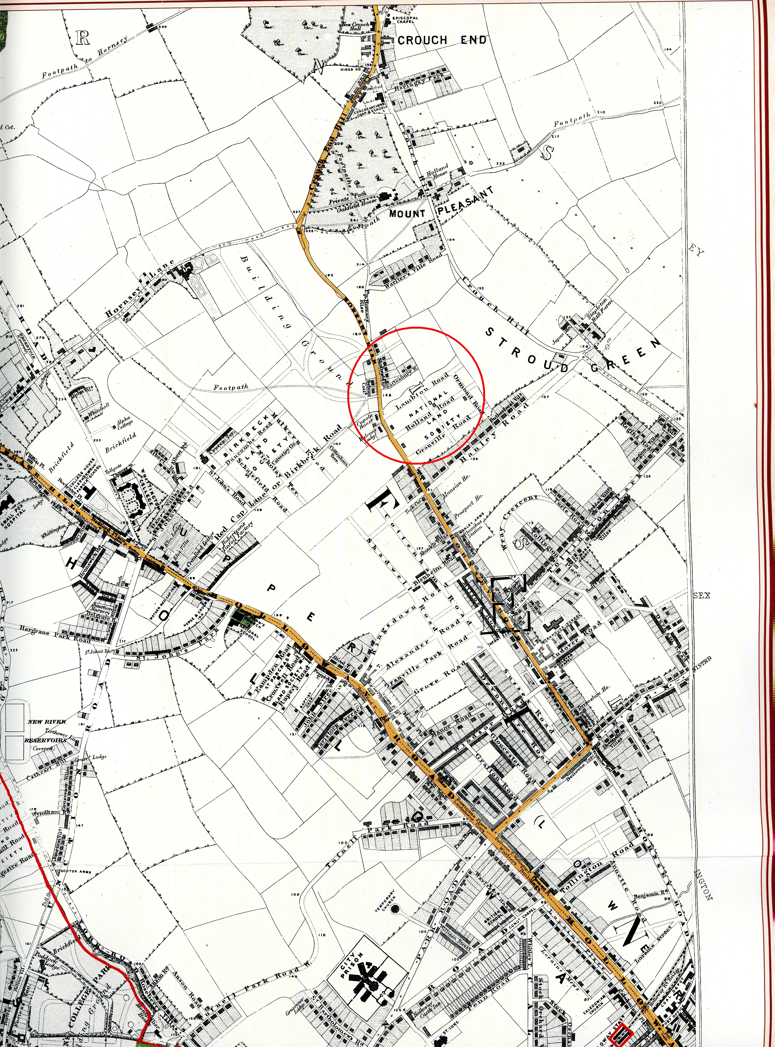
Before the land around Lambton Road, Ormond Road, Holland Road, etc, was developed, it was owned by The National Land Society as shown circled in red on the attached scan of part of an 1863 map of North West London. |
melgibbs |
Tuesday 22nd of April 2014 07:22:45 PM |