
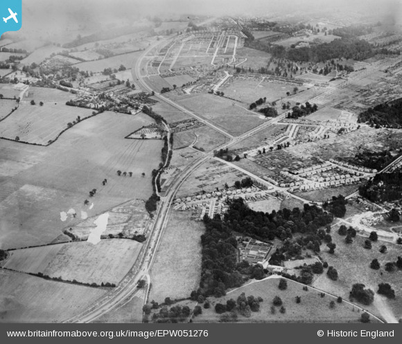
EPW051276 ENGLAND (1936). Housing development at Garston and Kingswood, Watford, 1936. This image has been produced from a damaged copy-negative.
© Copyright OpenStreetMap contributors and licensed by the OpenStreetMap Foundation. 2026. Cartography is licensed as CC BY-SA.
Details
| Title | [EPW051276] Housing development at Garston and Kingswood, Watford, 1936. This image has been produced from a damaged copy-negative. |
| Reference | EPW051276 |
| Date | July-1936 |
| Link | |
| Place name | WATFORD |
| Parish | |
| District | |
| Country | ENGLAND |
| Easting / Northing | 509533, 199670 |
| Longitude / Latitude | -0.41539548144324, 51.684630709197 |
| National Grid Reference | TQ095997 |
Pins

lm.1 |
Saturday 6th of May 2023 09:24:08 PM | |
|
lm.1 |
Saturday 6th of May 2023 09:22:30 PM | |
|
lm.1 |
Saturday 6th of May 2023 09:21:51 PM | |
|
lm.1 |
Saturday 6th of May 2023 09:20:46 PM | |
|
lm.1 |
Saturday 6th of May 2023 09:19:49 PM | |
|
lm.1 |
Saturday 6th of May 2023 09:18:51 PM | |
|
lm.1 |
Saturday 6th of May 2023 09:17:06 PM | |
|
lm.1 |
Saturday 6th of May 2023 09:16:04 PM | |
|
Susan |
Thursday 23rd of June 2022 11:41:16 AM | |
|
Susan |
Thursday 23rd of June 2022 11:40:32 AM | |
|
Susan |
Thursday 23rd of June 2022 11:39:52 AM | |
|
Susan |
Thursday 23rd of June 2022 11:39:30 AM | |
|
Paul |
Monday 29th of April 2019 07:25:06 PM | |
|
Paul |
Monday 29th of April 2019 06:30:52 PM | |
|
Paul |
Monday 29th of April 2019 03:51:58 PM | |
|
Paul |
Monday 29th of April 2019 03:49:29 PM | |
|
Paul |
Monday 29th of April 2019 03:48:22 PM |