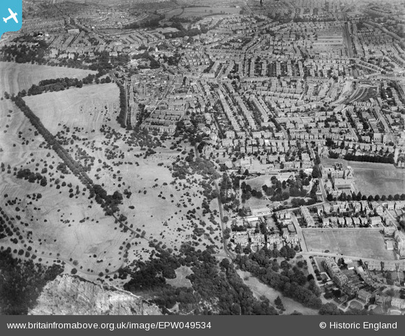
EPW049534 ENGLAND (1935). Clifton Down, Bristol Zoo and environs, Clifton, 1935
© Copyright OpenStreetMap contributors and licensed by the OpenStreetMap Foundation. 2026. Cartography is licensed as CC BY-SA.
Details
| Title | [EPW049534] Clifton Down, Bristol Zoo and environs, Clifton, 1935 |
| Reference | EPW049534 |
| Date | December-1935 |
| Link | |
| Place name | CLIFTON |
| Parish | |
| District | |
| Country | ENGLAND |
| Easting / Northing | 356962, 174252 |
| Longitude / Latitude | -2.6196195212671, 51.465112994168 |
| National Grid Reference | ST570743 |
Pins

Brian |
Wednesday 30th of December 2020 11:09:22 AM | |

Geoff |
Tuesday 5th of August 2014 01:46:27 PM | |

MB |
Tuesday 1st of October 2013 09:38:27 AM | |

MB |
Tuesday 1st of October 2013 09:35:19 AM | |

MB |
Tuesday 1st of October 2013 09:33:12 AM | |

MB |
Tuesday 1st of October 2013 09:32:33 AM | |

MB |
Tuesday 1st of October 2013 09:31:06 AM | |

MB |
Tuesday 1st of October 2013 09:28:49 AM | |

MB |
Tuesday 1st of October 2013 09:28:26 AM | |

MB |
Tuesday 1st of October 2013 09:28:01 AM | |

MB |
Tuesday 1st of October 2013 09:26:53 AM | |

MB |
Tuesday 1st of October 2013 09:26:15 AM | |

MB |
Tuesday 1st of October 2013 09:25:52 AM | |

MB |
Tuesday 1st of October 2013 09:25:17 AM | |

MB |
Tuesday 1st of October 2013 09:24:59 AM | |

Class31 |
Tuesday 1st of October 2013 09:23:19 AM | |

Class31 |
Tuesday 1st of October 2013 09:20:26 AM |

