
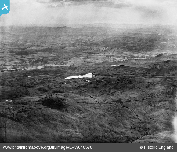
EPW048578 ENGLAND (1935). Gurnal Dubs and environs, Potter Fell, from the north-east, 1935
© Copyright OpenStreetMap contributors and licensed by the OpenStreetMap Foundation. 2026. Cartography is licensed as CC BY-SA.
Details
| Title | [EPW048578] Gurnal Dubs and environs, Potter Fell, from the north-east, 1935 |
| Reference | EPW048578 |
| Date | July-1935 |
| Link | |
| Place name | POTTER FELL |
| Parish | STRICKLAND ROGER |
| District | |
| Country | ENGLAND |
| Easting / Northing | 350671, 499874 |
| Longitude / Latitude | -2.7597775088009, 54.391808524241 |
| National Grid Reference | SD507999 |
Pins

Class31 |
Saturday 4th of May 2013 05:12:48 PM | |
|
Class31 |
Saturday 4th of May 2013 05:12:03 PM | |
|
Class31 |
Saturday 4th of May 2013 05:11:39 PM | |
|
Class31 |
Saturday 4th of May 2013 05:04:53 PM | |
|
Class31 |
Saturday 4th of May 2013 05:04:25 PM | |
|
Class31 |
Saturday 4th of May 2013 05:01:46 PM | |
|
Class31 |
Saturday 4th of May 2013 04:34:40 PM |
User Comment Contributions
Eureka Gurnal Dubbs looking south west over Staveley towards Windermere |
Class31 |
Tuesday 2nd of July 2013 01:03:31 PM |
Thank you... The original Aerofilms Ltd Register entry for the image says "Areas in the Lake District for Manchester Corporation Waterworks"; as you know we simply don't have enough leeway with our time to be able to hunt images like this out. It makes such as difference that website members can help with these. We'll update the catalogue and post the new record here in due course. Yours, Katy Britain from Above Cataloguing Team Leader |
Katy Whitaker |
Tuesday 2nd of July 2013 01:03:31 PM |
See also EPW048612. |

BigglesH |
Friday 17th of May 2013 11:26:44 AM |