
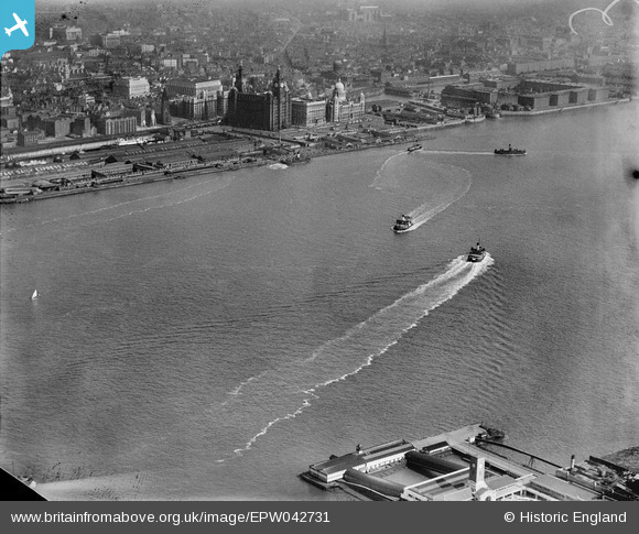
EPW042731 ENGLAND (1933). The River Mersey and Pier Head with the Royal Liver Building and Port of Liverpool Building in the distance, Liverpool, 1933
© Copyright OpenStreetMap contributors and licensed by the OpenStreetMap Foundation. 2025. Cartography is licensed as CC BY-SA.
Details
| Title | [EPW042731] The River Mersey and Pier Head with the Royal Liver Building and Port of Liverpool Building in the distance, Liverpool, 1933 |
| Reference | EPW042731 |
| Date | August-1933 |
| Link | |
| Place name | LIVERPOOL |
| Parish | |
| District | |
| Country | ENGLAND |
| Easting / Northing | 333112, 390590 |
| Longitude / Latitude | -3.0063003562829, 53.407620718613 |
| National Grid Reference | SJ331906 |
Pins

austin |
Wednesday 10th of February 2021 02:27:31 PM | |
|
austin |
Sunday 19th of April 2020 02:57:04 PM | |
|
austin |
Sunday 19th of April 2020 02:55:53 PM | |
|
austin |
Sunday 19th of April 2020 02:54:59 PM | |
|
austin |
Sunday 19th of April 2020 02:52:23 PM | |
|
Dave |
Thursday 17th of July 2014 05:20:58 PM | |
|
Dave |
Thursday 17th of July 2014 05:20:30 PM | |
|
Dave |
Thursday 17th of July 2014 05:19:54 PM | |
|
Dave |
Thursday 17th of July 2014 05:18:49 PM | |
|
Dave |
Thursday 17th of July 2014 05:18:04 PM | |
|
Dave |
Thursday 17th of July 2014 05:15:35 PM | |
 |

Class31 |
Monday 19th of August 2013 12:04:09 PM |
|
Class31 |
Monday 19th of August 2013 11:57:59 AM |


