
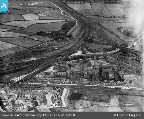
EPW042018 ENGLAND (1933). The Carnforth Iron Works, Carnforth, 1933
© Copyright OpenStreetMap contributors and licensed by the OpenStreetMap Foundation. 2026. Cartography is licensed as CC BY-SA.
Details
| Title | [EPW042018] The Carnforth Iron Works, Carnforth, 1933 |
| Reference | EPW042018 |
| Date | July-1933 |
| Link | |
| Place name | CARNFORTH |
| Parish | CARNFORTH |
| District | |
| Country | ENGLAND |
| Easting / Northing | 349686, 470969 |
| Longitude / Latitude | -2.7700904007462, 54.131928431418 |
| National Grid Reference | SD497710 |
Pins

John Wass |
Thursday 7th of June 2018 02:39:48 PM | |
|
John Wass |
Thursday 7th of June 2018 02:37:34 PM | |
|
John Wass |
Thursday 7th of June 2018 02:35:48 PM | |
|
lesgilpin |
Wednesday 29th of April 2015 11:04:27 AM | |
|
lesgilpin |
Wednesday 29th of April 2015 11:03:36 AM | |
|
lesgilpin |
Wednesday 29th of April 2015 10:56:31 AM | |
|
lesgilpin |
Wednesday 29th of April 2015 10:55:35 AM | |
|
lesgilpin |
Wednesday 29th of April 2015 10:54:59 AM | |
|
lesgilpin |
Wednesday 29th of April 2015 10:54:34 AM | |
|
Peter Turvey |
Friday 24th of April 2015 06:44:42 PM | |
|
Peter Turvey |
Friday 24th of April 2015 06:44:00 PM |