© Copyright OpenStreetMap contributors and licensed by the OpenStreetMap Foundation. 2024. Cartography is licensed as CC BY-SA.
Details
| Title |
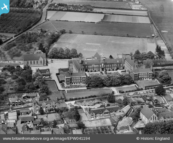
[EPW041194] Sutton Valence School, Sutton Valence, 1933 |
| Reference |
EPW041194 |
| Date |
May-1933 |
| Link |
|
| Place name |
SUTTON VALENCE |
| Parish |
SUTTON VALENCE |
| District |
|
| Country |
ENGLAND |
| Easting / Northing |
581214, 149341 |
| Longitude / Latitude |
0.59490421073384, 51.213957751719 |
| National Grid Reference |
TQ812493 |
Pins
 North Street |

totoro |
Monday 14th of April 2014 09:09:36 PM |
 School Chapel |

totoro |
Monday 14th of April 2014 09:06:36 PM |
 Sutton Valence School Block Erected 1910-1914, Sutton Valence
School Lane, Sutton Valence, Kent ME17 3LR
Grade 2 listed building - English Heritage Building ID: 174165
On 21 July 1911, the Archbishop of Canterbury, Randall Davidson, opened the new buildings, comprising the Main School and the St Margaret's, or Headmaster's Wing. The Westminster Wing was still under construction.
School founded 1576 by William Lambe.
It remained under the control of the Worshipful Company of Clothworkers until 1910 when it was taken under the control of United Westminster Schools, a charitable trust which also incorporates Emanuel School and Westminster City School in London.
School. 1910-14 by Adams, Holden and Pearson. Red brick in
English bond. South ends of wings stone on ground floor, tile-
hung above. Plain tile roofs. Courtyard plan, open to south,
with outward-turning south ends to side ranges and assembly
room projecting north from centre of north range.
In 1983, the school became co-educational and in 1995 it incorporated Underhill Preparatory School. It is now a co-educational day and boarding school catering for pupils from three to eighteen years of age. |

totoro |
Monday 14th of April 2014 09:05:42 PM |


![[EPW041194] Sutton Valence School, Sutton Valence, 1933](http://britainfromabove.org.uk/sites/all/libraries/aerofilms-images/public/100x100/EPW/041/EPW041194.jpg)
![[EPW041195] Sutton Valence School, Sutton Valence, 1933](http://britainfromabove.org.uk/sites/all/libraries/aerofilms-images/public/100x100/EPW/041/EPW041195.jpg)
![[EPW041192] Sutton Valence School, Sutton Valence, 1933](http://britainfromabove.org.uk/sites/all/libraries/aerofilms-images/public/100x100/EPW/041/EPW041192.jpg)
![[EPW041196] Sutton Valence School, Sutton Valence, 1933](http://britainfromabove.org.uk/sites/all/libraries/aerofilms-images/public/100x100/EPW/041/EPW041196.jpg)
![[EPW041191] Sutton Valence School, Sutton Valence, 1933](http://britainfromabove.org.uk/sites/all/libraries/aerofilms-images/public/100x100/EPW/041/EPW041191.jpg)