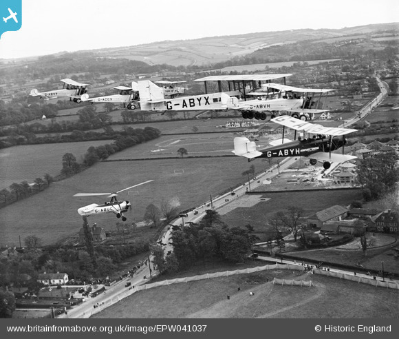
EPW041037 ENGLAND (1933). Hamsey Green, formation flying at the National Aviation Day air display, from the north-west, 1933
© Copyright OpenStreetMap contributors and licensed by the OpenStreetMap Foundation. 2026. Cartography is licensed as CC BY-SA.
Details
| Title | [EPW041037] Hamsey Green, formation flying at the National Aviation Day air display, from the north-west, 1933 |
| Reference | EPW041037 |
| Date | April-1933 |
| Link | |
| Place name | HAMSEY GREEN |
| Parish | WARLINGHAM |
| District | |
| Country | ENGLAND |
| Easting / Northing | 535048, 159454 |
| Longitude / Latitude | -0.061877920375856, 51.317639511362 |
| National Grid Reference | TQ350595 |
Pins

Mike |
Wednesday 17th of April 2024 06:44:53 PM | |

TerryhaynesBFA |
Wednesday 10th of May 2017 02:36:28 PM | |

melgibbs |
Saturday 30th of November 2013 04:07:53 PM | |

Kboj |
Friday 8th of November 2013 06:45:09 AM | |
Yes Kboj, you've got it! |

Class31 |
Friday 8th of November 2013 08:50:02 AM |

Kboj |
Saturday 2nd of November 2013 01:47:39 PM | |
Not in 1933. It would be either The National Provincial or Westminster. They merged to form NatWest(ugh!) in the late 1960's if memory serves. |

clippedwings |
Saturday 2nd of November 2013 10:29:33 PM |

Class31 |
Friday 1st of November 2013 08:41:19 PM | |
Isn't Upland Kenley - so that would be the other side of the Limpsfied Road? I think this may be Farleigh Road..?? |

TerryhaynesBFA |
Wednesday 10th of May 2017 02:23:46 PM |

Class31 |
Friday 1st of November 2013 08:34:12 PM | |

Class31 |
Friday 1st of November 2013 08:32:56 PM | |

Class31 |
Friday 1st of November 2013 08:29:19 PM | |

Class31 |
Friday 1st of November 2013 08:27:53 PM | |

Class31 |
Friday 1st of November 2013 08:27:11 PM | |

Rebecca |
Friday 1st of November 2013 04:38:41 PM | |
In my opinion it is a field. There is no dam wall or shoreline at the edge and there look to be small features such as bushes or animal feeders and undulations. |

Class31 |
Friday 1st of November 2013 04:51:07 PM |
No it is not a lake or body of water it was a large field. A few years later it was built upon. |

Doc Martin |
Saturday 22nd of November 2014 10:49:05 PM |
I'm pretty sure this is Kennel Farm, Chelsham Warlingham, which is a few minutes from where I live. It doesn't look like it was being used for aircraft at the time of this photo, but has been used as an airstrip and possibly Decoy site during WW2, and recently used for winch-launch paragliders from the Green Dragons flying school, who are based nearby in Woldingham. |

TerryhaynesBFA |
Wednesday 10th of May 2017 02:12:59 PM |

Croxley history |
Friday 20th of September 2013 06:00:21 PM | |

Croxley history |
Friday 20th of September 2013 05:54:39 PM |
User Comment Contributions
Does anyone have a complete list of the 1933 venues for the National Aviation Days? I have yet to find one. |

Class31 |
Friday 12th of May 2017 10:23:35 PM |
I have just joined BFA. Fantastic photos and history of Gardiner ( Gardener? ) airfield at Hamsey Green and Warlingham - where I live ( just by All Saints Church ). Thank you. There was another airfield at Kennel Farm in Warlingham but I can't find anything beyond some Google Earth images which clearly show the 'A' landing strip layout in the grass colour. Any information on this? Terry Haynes |

TerryhaynesBFA |
Thursday 27th of April 2017 06:41:10 PM |
I have this link which I hope helps. Thanks for all the work you've put into local history Class31- fascinating. http://afleetingpeace.org/index.php/aviators/c/14-business-and-pleasure/158-cobham-s-air-circus-1933-at-a-glance Terry Haynes |

TerryhaynesBFA |
Friday 12th of May 2017 10:23:35 PM |
I've just been looking ( again ) closer at this picture and there is something I don't understand. We are looking towards Warlingham with Tithe Pit Shaw lane in the right foreground. In fact I can see Ward Lane where my house was built in 1946 directly under G-ABYX's registration number. Which apparently places the Gardiner airfield on the left, almost directly opposite Tithe Pit Shaw Lane over Limpsfield Rd in what is now the Post Office sports Ground ( not the soccer field under the Cierva which now has Meadway estate, but the one to the left ). Which squares with all that I know. However there are no signs of aircraft or spectators there! None! However there are plenty of spectator / vehicle tracks exiting the field adjacent to Tithe Pit shaw lane so it seems that is where the air display was centred. I know that the Good Companions inn on the corner ( now demolished ) was opened in 1939. Or was Gardiner airfield on the opposite side of the road? |

TerryhaynesBFA |
Friday 12th of May 2017 12:11:25 AM |
Immediately to the left of the autogiro and about 300 yards further on was the site of Gardeners Aerodrome. It consisted of a large field and one tin hanger capable of holding two single engine biplane aircraft. The airfield was owned by a Mr Gardener who later after WWII became the "Air Correspondent" of the BBC. During WWII the airfield was used as a glider training school. Now most of the area under the aircraft in the picture has been built upon. |

Doc Martin |
Saturday 22nd of November 2014 10:57:16 PM |
Eureka We're on a duck shoot tonight. This is the fourth tonight! This is Hamsey Green Farm looking south along Limpsfield Road towards Warlingham where the National Aviation Day event took place on 29th and 30th April 1933. |

Class31 |
Monday 6th of January 2014 02:53:35 PM |
Bravo Class31! |

Rebecca |
Monday 4th of November 2013 02:17:19 PM |
Thanks for the location! It's good to be able to place more of these NADD events. We'll update the catalogue and post the new data here in due course. Yours, Katy Britain from Above Cataloguing Team Leader |
Katy Whitaker |
Monday 6th of January 2014 02:53:35 PM |
Warlingham 30th April. The landing field shows 2 days of use with the aircraft leaving for Faringdon I guess as the people seem to be dispersing. |

Kboj |
Saturday 2nd of November 2013 01:51:36 PM |
Planes flying: G-ABVY, G-ACCX, Tiger moth number not visible, G-ABYX, G-ABVH and G-ABYH, with rotor plane G-ABUC underneath. |

Rebecca |
Friday 1st of November 2013 04:28:15 PM |

