
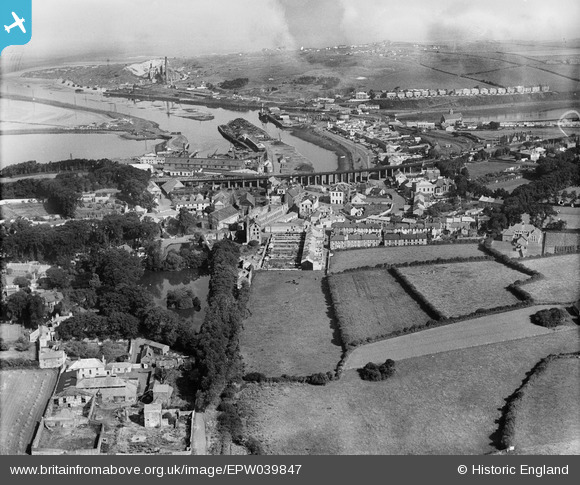
EPW039847 ENGLAND (1932). The town and the harbour, Hayle, from the south-east, 1932
© Copyright OpenStreetMap contributors and licensed by the OpenStreetMap Foundation. 2026. Cartography is licensed as CC BY-SA.
Details
| Title | [EPW039847] The town and the harbour, Hayle, from the south-east, 1932 |
| Reference | EPW039847 |
| Date | August-1932 |
| Link | |
| Place name | HAYLE |
| Parish | HAYLE |
| District | |
| Country | ENGLAND |
| Easting / Northing | 155929, 36819 |
| Longitude / Latitude | -5.4191225724515, 50.18040762702 |
| National Grid Reference | SW559368 |
Pins

MB |
Tuesday 20th of August 2013 11:02:44 PM | |
|
MB |
Tuesday 20th of August 2013 11:02:09 PM | |
|
MB |
Tuesday 20th of August 2013 11:00:37 PM | |
|
MB |
Tuesday 20th of August 2013 10:59:22 PM | |
|
MB |
Tuesday 20th of August 2013 10:57:01 PM | |
|
MB |
Tuesday 20th of August 2013 10:55:45 PM | |
|
MB |
Tuesday 20th of August 2013 10:54:19 PM | |
|
MB |
Tuesday 20th of August 2013 10:51:52 PM | |
|
MB |
Tuesday 20th of August 2013 10:50:41 PM | |
|
Graham Coad |
Tuesday 20th of August 2013 01:38:54 PM | |
|
Graham Coad |
Tuesday 20th of August 2013 01:37:59 PM | |
|
Graham Coad |
Tuesday 20th of August 2013 01:35:50 PM | |
|
Graham Coad |
Tuesday 20th of August 2013 01:28:31 PM | |
|
Graham Coad |
Tuesday 20th of August 2013 01:28:08 PM | |
|
Graham Coad |
Tuesday 20th of August 2013 01:21:44 PM | |
|
dave43 |
Saturday 18th of May 2013 09:52:32 PM | |
|
dave43 |
Saturday 18th of May 2013 09:51:36 PM |
User Comment Contributions
Members of the family who created the foundry, seen here in decay, are recorded in Edmund Vale's biography: The Harveys of Hayle. Published by Bradford Barton, Truro, in 1973 |
MB |
Tuesday 20th of August 2013 11:06:37 PM |