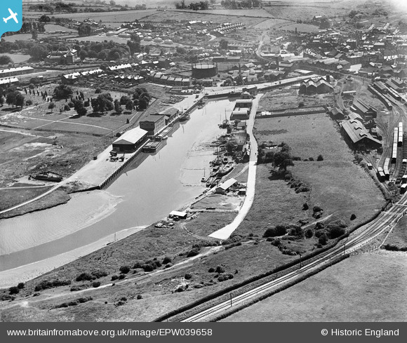
EPW039658 ENGLAND (1932). Newport Quay, Newport, 1932
© Copyright OpenStreetMap contributors and licensed by the OpenStreetMap Foundation. 2024. Cartography is licensed as CC BY-SA.
Details
| Title | [EPW039658] Newport Quay, Newport, 1932 |
| Reference | EPW039658 |
| Date | 12-August-1932 |
| Link | |
| Place name | NEWPORT |
| Parish | NEWPORT |
| District | |
| Country | ENGLAND |
| Easting / Northing | 450068, 89767 |
| Longitude / Latitude | -1.290889684451, 50.704807783556 |
| National Grid Reference | SZ501898 |
Pins
 Chris |
Tuesday 10th of December 2024 04:59:43 PM | |
 Chris |
Tuesday 10th of December 2024 04:52:48 PM | |
 Chris |
Tuesday 10th of December 2024 04:50:27 PM | |
 wessexpig |
Friday 23rd of August 2013 11:38:19 PM | |
 wessexpig |
Friday 23rd of August 2013 11:32:51 PM | |
 MB |
Monday 4th of February 2013 06:01:02 PM | |
 MB |
Monday 4th of February 2013 05:56:01 PM | |
 MB |
Monday 4th of February 2013 05:53:31 PM | |
 MB |
Monday 4th of February 2013 05:52:56 PM | |
 MB |
Monday 4th of February 2013 05:52:40 PM | |
 MB |
Monday 4th of February 2013 05:52:04 PM | |
 MB |
Monday 4th of February 2013 05:51:11 PM | |
 MB |
Monday 4th of February 2013 05:49:53 PM | |
 MB |
Monday 4th of February 2013 05:41:46 PM | |
All the locos on the I.O.W. are tank engines, anything else is too big. |
 John Wass |
Tuesday 25th of November 2014 09:07:19 PM |
User Comment Contributions
View looking south, roughly |
 MB |
Monday 4th of February 2013 06:01:39 PM |
Newport railway station was - before the Grouping in 1923 - on the Isle of Wight Central's line from Cowes to Ventnor Town |
 MB |
Monday 4th of February 2013 05:57:28 PM |
It was also the junction for lines eastwards to Haven Street and Smallbrook Junction and westwards to Freshwater |
 MB |
Monday 4th of February 2013 05:57:28 PM |

