
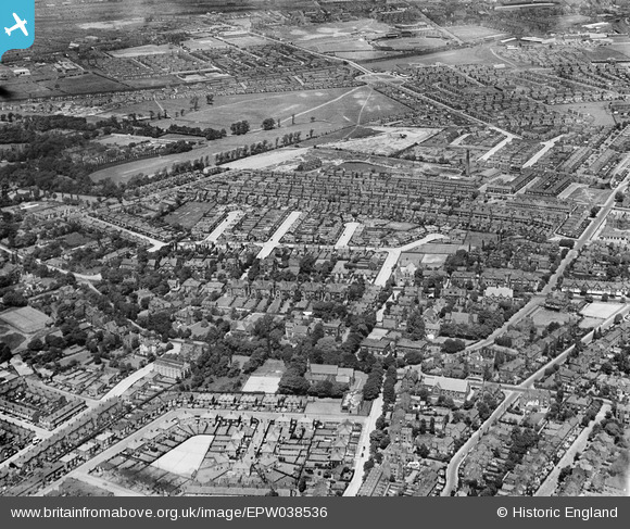
EPW038536 ENGLAND (1932). Housing surrounding Hewlett Road, Wilbraham Road and Longford Park, Chorlton-cum-Hardy, 1932
© Copyright OpenStreetMap contributors and licensed by the OpenStreetMap Foundation. 2026. Cartography is licensed as CC BY-SA.
Details
| Title | [EPW038536] Housing surrounding Hewlett Road, Wilbraham Road and Longford Park, Chorlton-cum-Hardy, 1932 |
| Reference | EPW038536 |
| Date | June-1932 |
| Link | |
| Place name | CHORLTON-CUM-HARDY |
| Parish | |
| District | |
| Country | ENGLAND |
| Easting / Northing | 381162, 394116 |
| Longitude / Latitude | -2.2836423666286, 53.443221007962 |
| National Grid Reference | SJ812941 |
Pins

thorcle |
Sunday 7th of February 2021 10:36:45 AM | |
|
JennyR |
Saturday 6th of April 2019 09:39:30 AM | |
|
Stretfordian |
Saturday 26th of August 2017 05:08:08 PM | |
|
Stretfordian |
Saturday 26th of August 2017 04:49:13 PM | |
|
Stretfordian |
Saturday 26th of August 2017 04:45:23 PM | |
|
John Ellis |
Wednesday 26th of July 2017 07:19:11 PM | |
|
John Ellis |
Wednesday 26th of July 2017 07:17:48 PM | |
|
John Ellis |
Wednesday 26th of July 2017 07:16:00 PM | |
|
John Ellis |
Wednesday 26th of July 2017 07:13:13 PM | |
|
John Ellis |
Wednesday 26th of July 2017 07:12:09 PM | |
|
John Ellis |
Wednesday 26th of July 2017 07:07:11 PM | |
|
John Ellis |
Wednesday 26th of July 2017 07:06:35 PM | |
|
John Ellis |
Wednesday 26th of July 2017 07:05:15 PM | |
|
John Ellis |
Wednesday 26th of July 2017 07:04:09 PM | |
|
John Ellis |
Wednesday 26th of July 2017 07:03:21 PM | |
|
John Ellis |
Wednesday 26th of July 2017 07:01:57 PM | |
|
John Ellis |
Wednesday 26th of July 2017 06:59:24 PM | |
|
John Ellis |
Wednesday 26th of July 2017 06:57:35 PM | |
|
John Ellis |
Wednesday 26th of July 2017 06:49:17 PM | |
|
John Ellis |
Wednesday 26th of July 2017 06:47:36 PM | |
|
John Ellis |
Wednesday 26th of July 2017 06:46:34 PM | |
|
John Ellis |
Wednesday 26th of July 2017 06:44:51 PM | |
|
John Ellis |
Wednesday 26th of July 2017 06:43:48 PM | |
|
John Ellis |
Wednesday 26th of July 2017 06:42:00 PM | |
|
John Ellis |
Wednesday 26th of July 2017 06:39:37 PM | |
|
John Ellis |
Wednesday 26th of July 2017 06:36:46 PM | |
|
John Ellis |
Wednesday 26th of July 2017 06:34:42 PM | |
|
John Ellis |
Wednesday 26th of July 2017 06:33:24 PM | |
|
John Ellis |
Wednesday 26th of July 2017 06:30:37 PM | |
|
John Ellis |
Wednesday 26th of July 2017 06:29:38 PM | |
|
John Ellis |
Wednesday 26th of July 2017 06:28:48 PM | |
|
John Ellis |
Wednesday 26th of July 2017 06:27:47 PM | |
|
John Ellis |
Wednesday 26th of July 2017 06:25:44 PM | |
|
John Ellis |
Wednesday 26th of July 2017 06:22:06 PM | |
|
John Ellis |
Wednesday 26th of July 2017 06:19:31 PM | |
|
John Ellis |
Wednesday 26th of July 2017 06:17:55 PM | |
|
John Ellis |
Wednesday 26th of July 2017 06:16:47 PM | |
|
John Ellis |
Wednesday 26th of July 2017 06:12:23 PM | |
|
Andrew |
Thursday 17th of October 2013 12:25:34 PM | |
Old Maps shows an electricity substation on this site, although it seems to have been expanded/rebuilt by the time of this photo. |
Tony D |
Thursday 17th of October 2013 01:22:52 PM |
|
Andrew |
Thursday 17th of October 2013 12:16:27 PM | |
|
Andrew |
Thursday 17th of October 2013 12:14:55 PM | |
|
Andrew |
Thursday 17th of October 2013 12:14:34 PM | |
|
Andrew |
Thursday 17th of October 2013 12:08:55 PM | |
|
Andrew |
Thursday 17th of October 2013 11:53:57 AM | |
|
MWM |
Sunday 16th of December 2012 08:43:02 AM |
