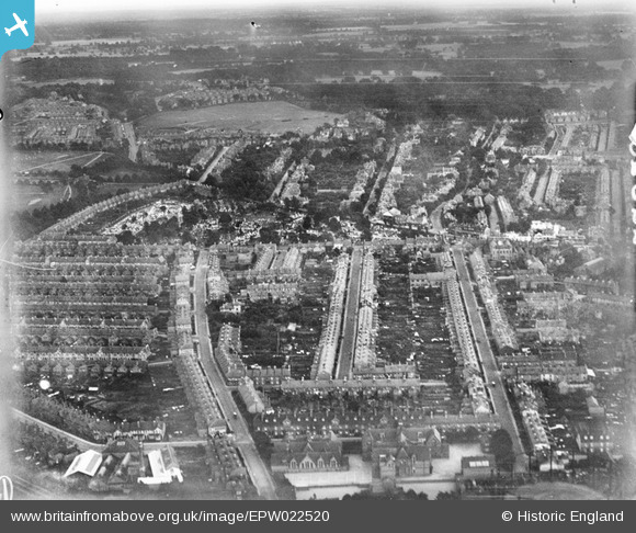
EPW022520 ENGLAND (1928). Reading Cemetery and environs, Reading, 1928
© Copyright OpenStreetMap contributors and licensed by the OpenStreetMap Foundation. 2026. Cartography is licensed as CC BY-SA.
Details
| Title | [EPW022520] Reading Cemetery and environs, Reading, 1928 |
| Reference | EPW022520 |
| Date | 11-August-1928 |
| Link | |
| Place name | READING |
| Parish | |
| District | |
| Country | ENGLAND |
| Easting / Northing | 473260, 173258 |
| Longitude / Latitude | -0.94554221690455, 51.453069942949 |
| National Grid Reference | SU733733 |
Pins

benmd |
Sunday 15th of April 2018 10:04:11 PM | |

benmd |
Sunday 15th of April 2018 10:03:08 PM | |

Class31 |
Thursday 11th of June 2015 08:09:25 AM | |

Class31 |
Thursday 11th of June 2015 08:08:43 AM | |

Norman W |
Saturday 20th of October 2012 02:47:02 PM | |

Norman W |
Saturday 20th of October 2012 02:42:14 PM | |

Norman W |
Saturday 20th of October 2012 02:40:24 PM | |

Norman W |
Thursday 27th of September 2012 05:57:14 PM | |

Norman W |
Thursday 27th of September 2012 05:55:51 PM | |

Norman W |
Thursday 27th of September 2012 05:52:07 PM | |

Norman W |
Thursday 27th of September 2012 05:47:27 PM |
User Comment Contributions
The Marquis of Granby PH, Reading, 10/06/2015 |

Class31 |
Thursday 11th of June 2015 08:11:47 AM |
Reading Old Cemetery, 10/06/2015 |

Class31 |
Thursday 11th of June 2015 08:10:56 AM |
River Kennet and Gasholder, Reading, 10/06/2015 |

Class31 |
Thursday 11th of June 2015 08:07:44 AM |
New Town Primary School, School Terrace, Reading, 10/06/2015 |

Class31 |
Thursday 11th of June 2015 08:06:41 AM |

